Home > Africa > Angola > Maps
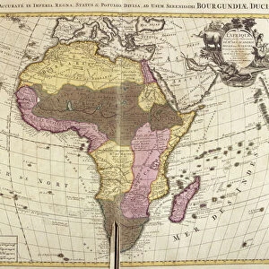
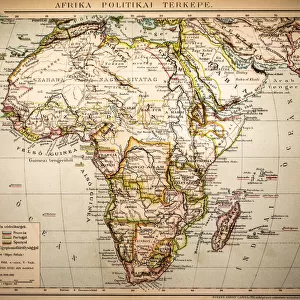
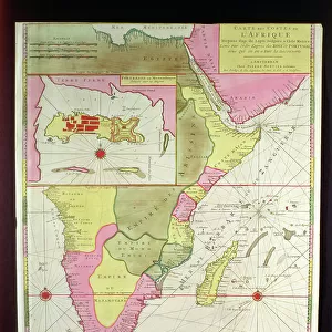
Map of Meridional Africa (Angola, Namibia, Zambia, Zimbabwe, Mozambique

![]()
Wall Art and Photo Gifts from Fine Art Finder
Map of Meridional Africa (Angola, Namibia, Zambia, Zimbabwe, Mozambique
LRI4706875 Map of Meridional Africa (Angola, Namibia, Zambia, Zimbabwe, Mozambique, South Africa) with the island of Madagascar (etching, 1730) by Delisle, Guillaume (1675-1726); Private Collection; (add.info.: Map of Meridional Africa (Angola, Namibia, Zambia, Zimbabwe, Mozambique, South Africa) with the island of Madagascar - Strong water extracted from the " New Atlas containing all parts of the world" 1730 by Guillaume de L Isle (1675-1726)); Luisa Ricciarini; French, out of copyright
Media ID 23734568
© Luisa Ricciarini / Bridgeman Images
Atlas Book Madagascar Mozambique Namibia Zimbabwe Geographical Map
FEATURES IN THESE COLLECTIONS
> Africa
> Angola
> Related Images
> Africa
> Madagascar
> Maps
> Africa
> Madagascar
> Related Images
> Africa
> Mozambique
> Maps
> Africa
> Mozambique
> Related Images
> Africa
> Namibia
> Related Images
> Africa
> Related Images
> Africa
> South Africa
> Maps
> Fine Art Finder
> Artists
> Guillaume Delisle
EDITORS COMMENTS
This print showcases a remarkable historical map titled "Map of Meridional Africa (Angola, Namibia, Zambia, Zimbabwe, Mozambique, South Africa) with the island of Madagascar". Created by Guillaume de L'Isle in 1730, this etching is a true testament to the artistry and precision of cartography during that era. The map encompasses various countries in southern Africa including Angola, Namibia, Zambia, Zimbabwe, Mozambique, and South Africa. It also features the stunning island of Madagascar. Delisle's attention to detail is evident as he accurately depicts geographical boundaries and landmarks. Taken from his renowned work "New Atlas containing all parts of the world" this particular map was extracted using strong water techniques. The result is an exquisite piece that not only serves as a geographical reference but also stands as a work of art in its own right. Luisa Ricciarini has expertly captured this historic print through her lens. The richness and intricacy of the original engraving are beautifully preserved in her photograph. This image allows us to appreciate both the artistic beauty and historical significance encapsulated within Delisle's creation. As we gaze upon this photo print, we are transported back to a time when exploration and discovery were at their peak. It reminds us of the vastness and diversity found within our world while honoring those who dedicated their lives to mapping it out for future generations.
MADE IN THE USA
Safe Shipping with 30 Day Money Back Guarantee
FREE PERSONALISATION*
We are proud to offer a range of customisation features including Personalised Captions, Color Filters and Picture Zoom Tools
SECURE PAYMENTS
We happily accept a wide range of payment options so you can pay for the things you need in the way that is most convenient for you
* Options may vary by product and licensing agreement. Zoomed Pictures can be adjusted in the Cart.