Home > Africa > South Africa > Maps
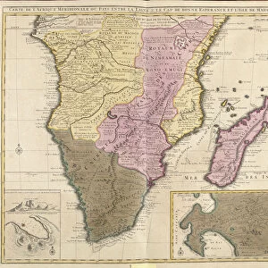
Map of Africa (etching, 1730)
")
![]()
Wall Art and Photo Gifts from Fine Art Finder
Map of Africa (etching, 1730)
LRI4706860 Map of Africa (etching, 1730) by Delisle, Guillaume (1675-1726); Private Collection; (add.info.: Map of Africa - Strong water extracted from the " New Atlas containing all parts of the world" 1730 by Guillaume de L Isle (1675-1726)); Luisa Ricciarini; French, out of copyright
Media ID 23734566
© Luisa Ricciarini / Bridgeman Images
FEATURES IN THESE COLLECTIONS
> Africa
> South Africa
> Maps
> Africa
> South Africa
> Related Images
> Fine Art Finder
> Artists
> Franz Hogenberg
> Fine Art Finder
> Artists
> Guillaume Delisle
> Maps and Charts
> Related Images
> Maps and Charts
> World
EDITORS COMMENTS
This print showcases a remarkable piece of cartographic history - the "Map of Africa" etching from 1730. Created by the renowned French cartographer Guillaume de L'Isle, this intricate map offers a fascinating glimpse into the geographical knowledge and artistic skill of the time. The etching depicts Africa in stunning detail, with its diverse landscapes and vast territories. From North Africa to South Africa, every region is meticulously outlined, providing an invaluable resource for explorers and scholars alike. The delicate lines and precise markings showcase De L'Isle's mastery in capturing both accuracy and beauty on paper. Originally featured in De L'Isle's comprehensive atlas titled "New Atlas containing all parts of the world" this particular map has stood the test of time as a testament to human curiosity about our planet. It serves as a reminder that even centuries ago, people were driven to explore and understand their surroundings. Thanks to Luisa Ricciarini's expert photography skills, we can now admire this historical masterpiece up close. The richness of colors and fine details captured in this print truly bring out the essence of De L'Isle's original work. Whether you are an art enthusiast or a lover of history, this print is sure to transport you back in time while igniting your sense of wonder about our ever-evolving world.
MADE IN THE USA
Safe Shipping with 30 Day Money Back Guarantee
FREE PERSONALISATION*
We are proud to offer a range of customisation features including Personalised Captions, Color Filters and Picture Zoom Tools
SECURE PAYMENTS
We happily accept a wide range of payment options so you can pay for the things you need in the way that is most convenient for you
* Options may vary by product and licensing agreement. Zoomed Pictures can be adjusted in the Cart.