Home > Europe > Spain > Maps
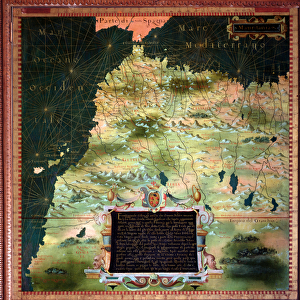
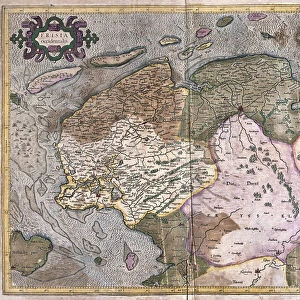
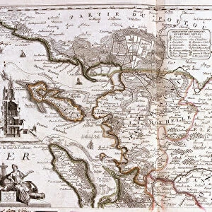
Map of Asturias (Spain) (Engraving, 1717)
 (Engraving, 1717)")
![]()
Wall Art and Photo Gifts from Fine Art Finder
Map of Asturias (Spain) (Engraving, 1717)
LRI4712680 Map of Asturias (Spain) (Engraving, 1717) by Nolin, Jean-Baptiste (c.1657-1708); Private Collection; (add.info.: Map of the Province of Asturias (Spain) - Engraving from the atlas le theatre du monde, 1717, by Jean Baptiste Nolin (1686-1762) - Map of Asturias (Spain) - From " Le Theatre du Monde" 1717 by Jean-Baptiste Nolin); Luisa Ricciarini; French, out of copyright
Media ID 23329280
© Luisa Ricciarini / Bridgeman Images
FEATURES IN THESE COLLECTIONS
> Europe
> Spain
> Related Images
> Fine Art Finder
> Artists
> Jean-Baptiste Nolin
> Fine Art Finder
> Artists
> Roberto Valturio
> Maps and Charts
> Related Images
> Maps and Charts
> Spain
EDITORS COMMENTS
This print showcases a remarkable engraving from 1717, depicting the Map of Asturias in Spain. Created by the talented Jean-Baptiste Nolin, this intricate map is part of his renowned atlas "Le Theatre du Monde". The province of Asturias comes to life through detailed geographical markings and precise cartographic techniques. Nolin's expertise in mapmaking is evident as he skillfully captures the essence of this Spanish region. Every contour and boundary is meticulously etched onto the surface, offering a glimpse into the landscape that existed over three centuries ago. From majestic mountains to winding rivers, each element contributes to an accurate representation of Asturias' geography. The historical significance of this engraving cannot be overstated. It provides invaluable insights into how people perceived and understood their surroundings during the 18th century. As we gaze upon this piece today, we are transported back in time, marveling at both its artistic beauty and scientific precision. Luisa Ricciarini has expertly captured this extraordinary work with her camera lens, preserving it for generations to come. Through her lens, we can appreciate every minute detail and immerse ourselves in the rich history encapsulated within Nolin's creation. This print serves as a testament to human curiosity and our unending quest for knowledge about our world. It reminds us that even centuries-old maps continue to inspire awe and fascination among art enthusiasts and historians alike.
MADE IN THE USA
Safe Shipping with 30 Day Money Back Guarantee
FREE PERSONALISATION*
We are proud to offer a range of customisation features including Personalised Captions, Color Filters and Picture Zoom Tools
SECURE PAYMENTS
We happily accept a wide range of payment options so you can pay for the things you need in the way that is most convenient for you
* Options may vary by product and licensing agreement. Zoomed Pictures can be adjusted in the Cart.