Home > Animals > Mammals > Muridae > Water Mouse
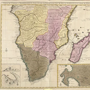
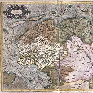
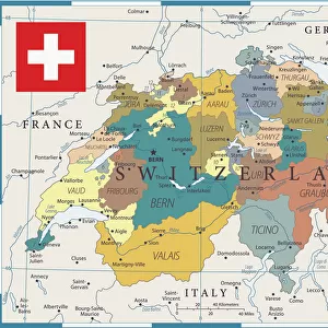
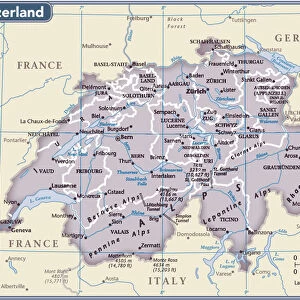
Map of the Swiss federation (etching, 1730)
")
![]()
Wall Art and Photo Gifts from Fine Art Finder
Map of the Swiss federation (etching, 1730)
LRI4706606 Map of the Swiss federation (etching, 1730) by Delisle, Guillaume (1675-1726); Private Collection; (add.info.: Map of the Swiss federation - Strong water extracted from the " New Atlas containing all parts of the world" 1730 by Guillaume de L Isle (1675-1726)); Luisa Ricciarini; French, out of copyright
Media ID 23328062
© Luisa Ricciarini / Bridgeman Images
FEATURES IN THESE COLLECTIONS
> Animals
> Mammals
> Muridae
> Water Mouse
> Europe
> Switzerland
> Maps
> Europe
> Switzerland
> Posters
> Europe
> Switzerland
> Related Images
> Fine Art Finder
> Artists
> Guillaume Delisle
> Maps and Charts
> Related Images
> Maps and Charts
> Switzerland
> Maps and Charts
> World
EDITORS COMMENTS
This print showcases a remarkable piece of cartographic history - the "Map of the Swiss federation" etching from 1730. Created by Guillaume Delisle, a renowned French geographer and cartographer, this map is an exquisite representation of Switzerland during the 18th century. The intricate details and precision in this etching are truly awe-inspiring. Every contour, river, and mountain range has been meticulously engraved to provide an accurate depiction of Switzerland's geography at that time. This map was extracted from Delisle's famous work, the "New Atlas containing all parts of the world" which solidified his reputation as one of the most influential cartographers of his era. Luisa Ricciarini has beautifully captured this historical artifact through her lens, bringing it to life for contemporary audiences to appreciate. The richness in colors and textures adds depth to every line on this centuries-old map. As we gaze upon this image, we are transported back in time to witness how Switzerland appeared over two centuries ago. It serves as a testament to human curiosity and our never-ending quest for knowledge about our surroundings. This print is not only a visual delight but also a valuable educational resource for those interested in European geography or historical maps. Its presence reminds us that art can be found even within scientific endeavors like cartography – merging beauty with functionality seamlessly.
MADE IN THE USA
Safe Shipping with 30 Day Money Back Guarantee
FREE PERSONALISATION*
We are proud to offer a range of customisation features including Personalised Captions, Color Filters and Picture Zoom Tools
SECURE PAYMENTS
We happily accept a wide range of payment options so you can pay for the things you need in the way that is most convenient for you
* Options may vary by product and licensing agreement. Zoomed Pictures can be adjusted in the Cart.