Home > Arts > Street art graffiti > Digital art > Vector illustrations
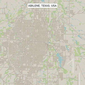
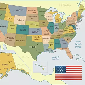
Carrollton Texas US City Street Map

![]()
Wall Art and Photo Gifts from Fine Art Storehouse
Carrollton Texas US City Street Map
Vector Illustration of a City Street Map of Carrollton, Texas, USA. Scale 1:60, 000.
All source data is in the public domain.
U.S. Geological Survey, US Topo
Used Layers:
USGS The National Map: National Hydrography Dataset (NHD)
USGS The National Map: National Transportation Dataset (NTD)
Unleash your creativity and transform your space into a visual masterpiece!
Frank Ramspott
Media ID 15192956
© Frank Ramspott, all rights reserved
Aerial View City Map Computer Graphic Directly Above Downtown District Gray Road Map Texas Text Carrollton Digitally Generated Image Green Color White Color
FEATURES IN THESE COLLECTIONS
> Aerial Photography
> Related Images
> Animals
> Insects
> Hemiptera
> Green Scale
> Arts
> Contemporary art
> Digital artwork
> Street art
> Arts
> Landscape paintings
> Waterfall and river artworks
> River artworks
> Arts
> Portraits
> Pop art gallery
> Street art portraits
> Arts
> Street art graffiti
> Digital art
> Digital paintings
> Arts
> Street art graffiti
> Digital art
> Vector illustrations
> Fine Art Storehouse
> Map
> Street Maps
> Fine Art Storehouse
> Map
> USA Maps
> Maps and Charts
> Geological Map
> Maps and Charts
> Related Images
> North America
> United States of America
> Lakes
> Related Images
EDITORS COMMENTS
This print showcases a detailed and meticulously crafted city street map of Carrollton, Texas, USA. With a scale of 1:60,000, every intricate detail is brought to life in this vector illustration. The artist has skillfully utilized various layers from the USGS The National Map to create this stunning piece. The map encompasses the entirety of Carrollton's downtown district, highlighting its vibrant streets and bustling city life. It also features the serene beauty of nearby lakes and rivers that add charm to this Texan town. The roadways are clearly marked, providing an accurate representation of the city's transportation network. Displayed in striking colors such as gray, blue, white, and green; this digitally generated image captures both the physical geography and cartography of Carrollton with precision. Taken from an aerial view directly above the cityscape, it offers a unique perspective on its layout. With no people present in the image itself, all focus is directed towards appreciating the artistry behind this visually appealing creation. Designed by Frank Ramspott using public domain source data from U. S Geological Survey (USGS), specifically their National Hydrography Dataset (NHD) and National Transportation Dataset (NTD). This remarkable print serves as an excellent addition for any art enthusiast or admirer of maps seeking to celebrate Carrollton's distinct character through fine art photography.
MADE IN THE USA
Safe Shipping with 30 Day Money Back Guarantee
FREE PERSONALISATION*
We are proud to offer a range of customisation features including Personalised Captions, Color Filters and Picture Zoom Tools
SECURE PAYMENTS
We happily accept a wide range of payment options so you can pay for the things you need in the way that is most convenient for you
* Options may vary by product and licensing agreement. Zoomed Pictures can be adjusted in the Cart.