Home > Arts > Street art graffiti > Digital art > Vector illustrations
Grand Prairie Texas US City Street Map

![]()
Wall Art and Photo Gifts from Fine Art Storehouse
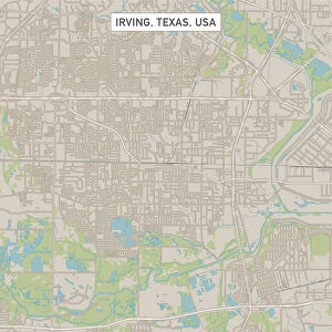
Grand Prairie Texas US City Street Map
Vector Illustration of a City Street Map of Grand Prairie, Texas, USA. Scale 1:60, 000.
All source data is in the public domain.
U.S. Geological Survey, US Topo
Used Layers:
USGS The National Map: National Hydrography Dataset (NHD)
USGS The National Map: National Transportation Dataset (NTD)
Unleash your creativity and transform your space into a visual masterpiece!
Frank Ramspott
Media ID 15192946
© Frank Ramspott, all rights reserved
Aerial View City Map Computer Graphic Directly Above Downtown District Gray Road Map Texas Text Digitally Generated Image Green Color White Color
FEATURES IN THESE COLLECTIONS
> Aerial Photography
> Related Images
> Animals
> Insects
> Hemiptera
> Green Scale
> Arts
> Contemporary art
> Digital artwork
> Street art
> Arts
> Landscape paintings
> Waterfall and river artworks
> River artworks
> Arts
> Portraits
> Pop art gallery
> Street art portraits
> Arts
> Street art graffiti
> Digital art
> Digital paintings
> Arts
> Street art graffiti
> Digital art
> Vector illustrations
> Fine Art Storehouse
> Map
> Street Maps
> Fine Art Storehouse
> Map
> USA Maps
> Maps and Charts
> Geological Map
> Maps and Charts
> Related Images
> North America
> United States of America
> Lakes
> Related Images
EDITORS COMMENTS
This print showcases a detailed and vibrant city street map of Grand Prairie, Texas, USA. The vector illustration depicts the downtown district, encompassing various landmarks such as lakes, rivers, streets, and roads. With a scale of 1:60,000, this meticulously crafted artwork provides an accurate representation of the city's cartography. The artist behind this digitally generated image is Frank Ramspott. Utilizing public domain source data from the U. S Geological Survey (USGS) - The National Map: National Hydrography Dataset (NHD) and National Transportation Dataset (NTD), Ramspott has created a visually stunning aerial view directly above Grand Prairie. The color palette used in this design includes shades of gray, blue, white, and green which beautifully complement each other to bring out the physical geography of the area. This print is perfect for those who appreciate both artistry and functionality as it seamlessly combines elements of computer graphics with real-world mapping. Whether you are a resident or visitor to Grand Prairie or simply have an affinity for urban landscapes and maps, this print will undoubtedly captivate your attention. Hang it on your wall to add a touch of sophistication while showcasing your love for cartography and design.
MADE IN THE USA
Safe Shipping with 30 Day Money Back Guarantee
FREE PERSONALISATION*
We are proud to offer a range of customisation features including Personalised Captions, Color Filters and Picture Zoom Tools
SECURE PAYMENTS
We happily accept a wide range of payment options so you can pay for the things you need in the way that is most convenient for you
* Options may vary by product and licensing agreement. Zoomed Pictures can be adjusted in the Cart.