Home > Arts > Artists > C > Abraham Cresques
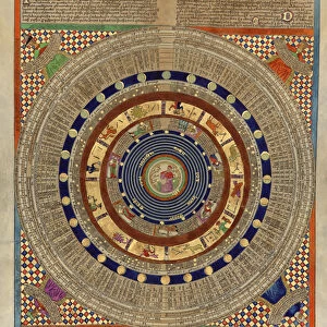
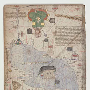
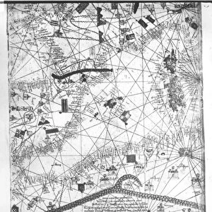
Four vellum leaves of the Catalan Atlas, 1375 (pen and coloured inks on parchment)
")
![]()
Wall Art and Photo Gifts from Fine Art Finder
Four vellum leaves of the Catalan Atlas, 1375 (pen and coloured inks on parchment)
5895292 Four vellum leaves of the Catalan Atlas, 1375 (pen and coloured inks on parchment) by Cresques, Abraham (1325-87); Bibliotheque Nationale, Paris, France; (add.info.: World map made in Majorca, with Jerusalem close to the centre, attributed to the Jewish cartographer Abraham Cresques in the service of the king of Aragon. One of the few surviving examples of medieval cartography, richly illustrated and covers an area from the Atlantic to China, from Scandinavia to the Rio Oro in Africa in six parchment-covered wooden panels.); Spanish, out of copyright
Media ID 23569736
© Bridgeman Images
Atlas Catalan Catalan Atlas Catalonia Compass Compass Lines Cosmography Hydrography Majorcan Mappa Mundi Nautical Navigation Navigational Portolan Sea Chart Silk Road Spice Trade Spices Vellum World Map
FEATURES IN THESE COLLECTIONS
> Africa
> Related Images
> Arts
> Art Movements
> Medieval Art
> Arts
> Artists
> C
> Abraham Cresques
> Arts
> Artists
> O
> Oceanic Oceanic
> Asia
> China
> China Heritage Sites
> Silk Roads: the Routes Network of
> Europe
> France
> Paris
> Maps
> Europe
> France
> Paris
> Related Images
> Fine Art Finder
> Artists
> Abraham Cresques
> Fine Art Finder
> Artists
> Nathan B. Abbott
EDITORS COMMENTS
This print showcases four vellum leaves of the Catalan Atlas, a remarkable piece of medieval cartography created in 1375 by Abraham Cresques. Crafted with pen and colored inks on parchment, this world map was made in Majorca under the patronage of the king of Aragon. Preserved at the Bibliotheque Nationale in Paris, France, these leaves offer a glimpse into the rich history and artistry of cartography during the 14th century. The Catalan Atlas is one of the few surviving examples from this era and is renowned for its intricate illustrations covering an extensive geographic area. From Scandinavia to China, from Africa's Rio Oro to the Atlantic Ocean, this comprehensive map provides a visual representation that spans continents and oceans. Of particular interest is Jerusalem's prominent placement near the center—a testament to its significance as a religious hub during that time. The atlas also offers insights into trade routes such as the Silk Road and maritime exploration along coastlines. With meticulous attention to detail, Cresques skillfully incorporated navigational elements like compass lines and hydrography into his work. This masterpiece not only serves as a navigational tool but also reflects cultural exchanges between different regions through commerce and spice trade. As we admire this extraordinary artwork captured in print form by Bridgeman Images, we are transported back in time to an era when maps were meticulously crafted by hand—each stroke representing both geographical knowledge and artistic expression.
MADE IN THE USA
Safe Shipping with 30 Day Money Back Guarantee
FREE PERSONALISATION*
We are proud to offer a range of customisation features including Personalised Captions, Color Filters and Picture Zoom Tools
SECURE PAYMENTS
We happily accept a wide range of payment options so you can pay for the things you need in the way that is most convenient for you
* Options may vary by product and licensing agreement. Zoomed Pictures can be adjusted in the Cart.