Home > Arts > Artists > C > Abraham Cresques
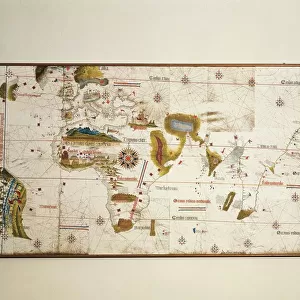
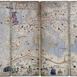
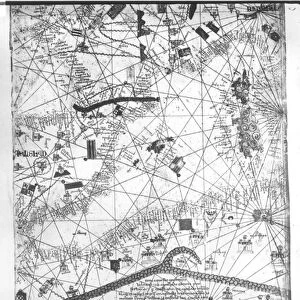
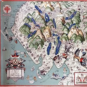
Catalan Atlas, Sheet 9, 1375 (pen and coloured inks on parchment)
")
![]()
Wall Art and Photo Gifts from Fine Art Finder
Catalan Atlas, Sheet 9, 1375 (pen and coloured inks on parchment)
5054647 Catalan Atlas, Sheet 9, 1375 (pen and coloured inks on parchment) by Cresques, Abraham (1325-87); Bibliotheque Nationale, Paris, France; (add.info.: World map made in Majorca, with Jerusalem close to the centre, attributed to the Jewish cartographer Abraham Cresques in the service of the king of Aragon. One of the few surviving examples of medieval cartography, richly illustrated and covers an area from the Atlantic to China, from Scandinavia to the Rio Oro in Africa in six parchment-covered wooden panels.); Spanish, out of copyright
Media ID 23573890
© Bridgeman Images
Arabia Atlas Black Sea Catalan Catalan Atlas Catalonia Compass Compass Lines Cosmography Early Map Hydrography Majorcan Mappa Mundi Mediterranean Nautical Nautical Charts Navigation Navigational Portolan Sea Chart Silk Road Spice Trade Spices Vellum World Map
FEATURES IN THESE COLLECTIONS
> Africa
> Related Images
> Arts
> Art Movements
> Medieval Art
> Arts
> Artists
> C
> Abraham Cresques
> Arts
> Artists
> O
> Oceanic Oceanic
> Asia
> China
> China Heritage Sites
> Silk Roads: the Routes Network of
> Asia
> Turkey
> Related Images
> Europe
> France
> Paris
> Maps
> Fine Art Finder
> Artists
> Abraham Cresques
EDITORS COMMENTS
This print showcases the Catalan Atlas, Sheet 9, a remarkable piece of medieval cartography created in 1375 by Abraham Cresques. The map was crafted in Majorca and is attributed to the Jewish cartographer who served the king of Aragon. Preserved in the Bibliotheque Nationale in Paris, France, this world map offers a unique glimpse into historical geography. The Catalan Atlas covers an extensive area from Scandinavia to China and from the Atlantic Ocean to Africa's Rio Oro. It is richly illustrated with pen and colored inks on parchment spread across six wooden panels. Notably, Jerusalem sits close to the center of this intricate map. As one of few surviving examples of medieval cartography, this masterpiece provides valuable insights into early navigation and trade routes. It depicts important landmarks such as coastlines, ports, compass lines, and even includes details about spice trade along the Silk Road. The intricacy and attention to detail showcased within this work highlight its significance not only as a navigational tool but also as a testament to human curiosity and exploration during that era. The Catalan Atlas serves as a reminder of how our ancestors sought knowledge beyond their immediate surroundings while shaping our understanding of the world we inhabit today.
MADE IN THE USA
Safe Shipping with 30 Day Money Back Guarantee
FREE PERSONALISATION*
We are proud to offer a range of customisation features including Personalised Captions, Color Filters and Picture Zoom Tools
SECURE PAYMENTS
We happily accept a wide range of payment options so you can pay for the things you need in the way that is most convenient for you
* Options may vary by product and licensing agreement. Zoomed Pictures can be adjusted in the Cart.