Home > Africa > Ethiopia > Related Images
Map of Africa, with travellers routes

![]()
Wall Art and Photo Gifts from Mary Evans Picture Library
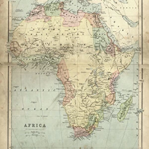
Map of Africa, with travellers routes
Map of Africa, with the routes of the modern travellers, Parke, Browne and Le Vaillant.
1799
Mary Evans Picture Library makes available wonderful images created for people to enjoy over the centuries
Media ID 14416346
© Mary Evans Picture Library
1790s 1799 Arabia Browne Continent Ethiopia Guinea Leone Madagascar Maps Mediterranean Parke Routes Sierra Syria Travellers Vaillant
FEATURES IN THESE COLLECTIONS
> Africa
> Ethiopia (Abyssinia)
> Related Images
> Africa
> Ethiopia
> Related Images
> Africa
> Guinea
> Related Images
> Africa
> Madagascar
> Maps
> Africa
> Madagascar
> Related Images
> Africa
> Related Images
> Africa
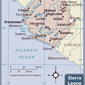
> Sierra Leone
> Maps
> Africa
> Sierra Leone
> Related Images
> Arts
> Artists
> O
> Oceanic Oceanic
EDITORS COMMENTS
This hand-coloured map, dating back to 1799, offers a fascinating glimpse into the exploratory spirit of the 1790s as it depicts Africa with the recorded routes of notable travellers Parke, Browne, and Le Vaillant. The map, held in the esteemed collection of Mary Evans Picture Library, provides a detailed representation of the African continent during a time when European exploration was at its height. The map is adorned with intricate colouring, highlighting various geographical features such as the vast Sahara Desert, the Nile River, and the Red Sea. The Mediterranean Sea and the Indian Ocean encircle the continent, reflecting the significance of maritime exploration during this era. The map also shows the territories of Spain and Portugal, reflecting their colonial influence in Africa. At the bottom of the map, the routes of Parke, Browne, and Le Vaillant are marked, providing a testament to their intrepid journeys across the African continent. Parke's route is shown from Tripoli to Timbuktu, Browne's from the Mediterranean to the Cape of Good Hope, and Le Vaillant's from the Cape of Good Hope to Ethiopia. These explorers' accounts provided valuable information about the African continent, contributing to the growing body of knowledge about the diverse cultures, landscapes, and peoples of Africa. The map also features labels for various African countries, including Madagascar, Ethiopia, Sierra Leone, and Guinea, among others. The map's intricate details and historical significance make it an essential resource for scholars, historians, and anyone interested in the history of exploration and the African continent.
MADE IN THE USA
Safe Shipping with 30 Day Money Back Guarantee
FREE PERSONALISATION*
We are proud to offer a range of customisation features including Personalised Captions, Color Filters and Picture Zoom Tools
SECURE PAYMENTS
We happily accept a wide range of payment options so you can pay for the things you need in the way that is most convenient for you
* Options may vary by product and licensing agreement. Zoomed Pictures can be adjusted in the Cart.