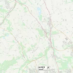
Home > Europe > United Kingdom > Wales > Mid Glamorgan > Bridgend
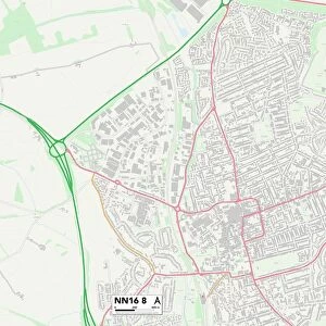
Daventry NN6 6 Map

![]()
Wall Art and Photo Gifts from Map Marketing
Daventry NN6 6 Map
Postcode Sector Map of Daventry NN6 6
Media ID 19975954
Abbey View Bridgend Bridle Lane Brookside Close Church Lane Church Street Court Lane Crabtree Lane Crick Road Daventry Hall Close Hall Lane High Street Kings Lane Main Street Millers Road Naseby Road Newlands Newlands Road Northampton Road School Close School Lane Stanford Close Stanford Road The Leys Wards Lane Welford Road West End West Street Westfield Crescent Elkington Knights Hill Naseby Welford
FEATURES IN THESE COLLECTIONS
> Europe
> United Kingdom
> England
> Avon
> Europe
> United Kingdom
> Scotland
> West Lothian
> Bridgend
> Europe
> United Kingdom
> Wales
> Mid Glamorgan
> Bridgend
> Map Marketing
> Postcode Sector Maps
> NN - Northampton
> Maps and Charts
> Related Images
MADE IN THE USA
Safe Shipping with 30 Day Money Back Guarantee
FREE PERSONALISATION*
We are proud to offer a range of customisation features including Personalised Captions, Color Filters and Picture Zoom Tools
SECURE PAYMENTS
We happily accept a wide range of payment options so you can pay for the things you need in the way that is most convenient for you
* Options may vary by product and licensing agreement. Zoomed Pictures can be adjusted in the Cart.