Home > Europe > United Kingdom > Wales > Flintshire > Flint
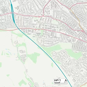
Dartford DA10 0 Map

![]()
Wall Art and Photo Gifts from Map Marketing
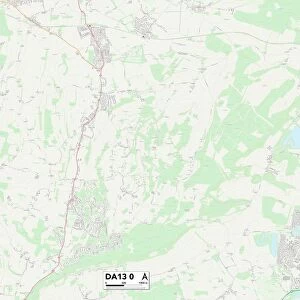
Dartford DA10 0 Map
Postcode Sector Map of Dartford DA10 0
Media ID 19968686
Alamein Road Albert Road All Saints Close Alma Road Bailey Close Broad Road Broomfield Road Castle Road Castle Street Cherry Orchard Church Road Dartford Freeman Close Gilbert Close Glover Close Herbert Road High Street Hope Road Leonard Avenue Lewis Road Manor Road Manor Way Mason Avenue Mayfield Milton Road Milton Street Moore Road Orchard Road Owen Close Park Road Raven Close Rectory Road Roberts Lane St Pauls Close St Peters Close Stanhope Road Stanley Road The Grove Vernon Road Wallace Gardens Wilson Close Wright Close Swanscombe
FEATURES IN THESE COLLECTIONS
> Animals
> Mammals
> Muridae
> Peters Mouse
> Arts
> Artists
> H
> Robert Hills
> Arts
> Artists
> R
> Leonard Raven-Hill
> Arts
> Artists
> S
> Owen Stanley
> Arts
> Artists
> S
> Robert Seymour
> Arts
> Artists
> W
> Wilson Wilson
> Europe
> United Kingdom
> Wales
> Flintshire
> Flint
> Map Marketing
> Postcode Sector Maps
> DA - Dartford
> Maps and Charts
> Related Images
MADE IN THE USA
Safe Shipping with 30 Day Money Back Guarantee
FREE PERSONALISATION*
We are proud to offer a range of customisation features including Personalised Captions, Color Filters and Picture Zoom Tools
SECURE PAYMENTS
We happily accept a wide range of payment options so you can pay for the things you need in the way that is most convenient for you
* Options may vary by product and licensing agreement. Zoomed Pictures can be adjusted in the Cart.