Home > Europe > United Kingdom > Wales > Powys > Montgomery
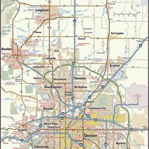
MA Hampden Russell Vector Road Map

![]()
Wall Art and Photo Gifts from Fine Art Storehouse
MA Hampden Russell Vector Road Map
MA Hampden Russell Vector Road Map. All source data is in the public domain. U.S. Census Bureau Census Tiger. Used Layers: areawater, linearwater, roads, rails, cousub, pointlm, uac10
Unleash your creativity and transform your space into a visual masterpiece!
Frank Ramspott
Media ID 20690509
© Frank Ramspott, all rights reserved
City Map Computer Graphic County Digital Composite District Geographical Border Hampden Massachusetts Road Map Russell Text Vector Digitally Generated Image Montgomery
FEATURES IN THESE COLLECTIONS
> Animals
> Mammals
> Cats (Wild)
> Tiger
> Animals
> Mammals
> Muridae
> Water Mouse
> Arts
> Contemporary art
> Digital artwork
> Street art
> Arts
> Landscape paintings
> Waterfall and river artworks
> River artworks
> Arts
> Portraits
> Pop art gallery
> Street art portraits
> Arts
> Street art graffiti
> Digital art
> Digital paintings
> Europe
> United Kingdom
> Wales
> Powys
> Montgomery
> Fine Art Storehouse
> Map
> Reference Maps
> Maps and Charts
> Related Images
> Popular Themes
> Lake District
EDITORS COMMENTS
This print titled "MA Hampden Russell Vector Road Map" showcases a meticulously designed and digitally generated image of Massachusetts' Hampden County district. The artist, Frank Ramspott, skillfully combines various layers sourced from the public domain, including U. S. Census Bureau Census Tiger data such as areawater, linearwater, roads, rails, cousub, pointlm, and uac10. The vibrant color image features a vector representation of the region's physical geography with no people present in the frame. The intricate cartography highlights geographical borders while incorporating city maps and street details for enhanced clarity. Rivers and lakes gracefully meander across the landscape adding to its visual allure. Noteworthy landmarks like Tekoa Mountain, Montgomery, Russellville, Russell Mountain Woronoco Heights Tarrot Hill Wyben Mundale South Quarter can be spotted on this comprehensive road map. With an ID number of 1303628966 associated with it (not related to any company), this artwork is a testament to Ramspott's artistic prowess. Perfect for those fascinated by cartography or seeking aesthetic wall decor that celebrates their love for Massachusetts' Hampden County district; this digital composite offers an engaging glimpse into the area's topography and urban layout
MADE IN THE USA
Safe Shipping with 30 Day Money Back Guarantee
FREE PERSONALISATION*
We are proud to offer a range of customisation features including Personalised Captions, Color Filters and Picture Zoom Tools
SECURE PAYMENTS
We happily accept a wide range of payment options so you can pay for the things you need in the way that is most convenient for you
* Options may vary by product and licensing agreement. Zoomed Pictures can be adjusted in the Cart.