Home > Europe > France > Paris > Maps
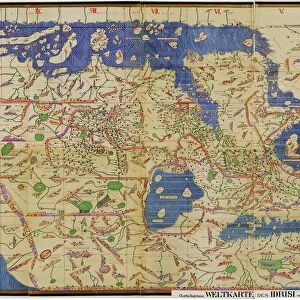
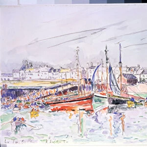
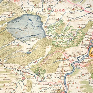
Illustration of the differing measurements of the league in Germany, Brabant

![]()
Wall Art and Photo Gifts from Fine Art Finder
Illustration of the differing measurements of the league in Germany, Brabant
CHT331721 Illustration of the differing measurements of the league in Germany, Brabant, France and Italy, from Theatre des guerres entre le roy d espagne et les Estats de Hollande, known as the Atlas de Richelieu (coloured engraving) by Langren, Arnold Florent van (1571-1644); Archives du Ministere des Affaires Etrangeres, Paris, France; (add.info.: Echelle de diverses lieues; scale model of distances at the time of the Thirty years War; A.F. de Langren came from a dynasty of cartographers and globe makers and was Cosmographe or Spherographe to King Philip IV of Spain (1605-65); a league equals approximately 5.5 kilometres or 3.5 miles; ); eArchives Charmet; Dutch, out of copyright
Media ID 23205352
© Archives Charmet / Bridgeman Images
FEATURES IN THESE COLLECTIONS
> Europe
> France
> Paris
> Maps
> Europe
> France
> Paris
> Related Images
> Europe
> Spain
> Related Images
> Fine Art Finder
> Artists
> Arnold Florent van Langren
> Fine Art Finder
> Artists
> Thomas Couture
> Fine Art Finder
> Maps (celestial & Terrestrial)
EDITORS COMMENTS
This print showcases an exquisite illustration of the differing measurements of the league in Germany, Brabant, France, and Italy. Taken from the renowned Atlas de Richelieu, this coloured engraving by Arnold Florent van Langren offers a fascinating glimpse into the scale model of distances during the tumultuous era of the Thirty Years War. Langren, belonging to a distinguished lineage of cartographers and globe makers, served as Cosmographe or Spherographe to King Philip IV of Spain. His expertise is evident in this meticulously crafted artwork that highlights various compasses and maps alongside detailed measurements. The image not only captures historical significance but also provides valuable insights into how distances were perceived at that time. It reminds us that a league equated to approximately 5.5 kilometers or 3.5 miles during this period. Preserved within the archives of the Ministry of Foreign Affairs in Paris, France, this precious piece exemplifies Langren's mastery as an artist and geographer. The vibrant colors breathe life into his creation while showcasing his attention to detail. As we delve into this mesmerizing print from Fine Art Finder's collection courtesy of Bridgeman Images, we are transported back in time to witness an era where cartography played a crucial role in understanding geographical boundaries and measuring vast distances across Europe.
MADE IN THE USA
Safe Shipping with 30 Day Money Back Guarantee
FREE PERSONALISATION*
We are proud to offer a range of customisation features including Personalised Captions, Color Filters and Picture Zoom Tools
SECURE PAYMENTS
We happily accept a wide range of payment options so you can pay for the things you need in the way that is most convenient for you
* Options may vary by product and licensing agreement. Zoomed Pictures can be adjusted in the Cart.