Home > Europe > Related Images
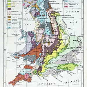
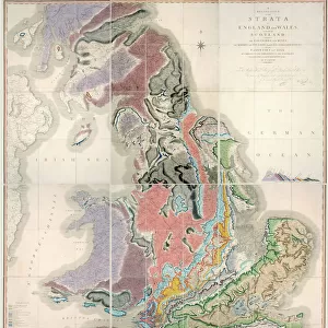
Geological map, South-East England, 1830s

![]()
Wall Art and Photo Gifts from Science Photo Library
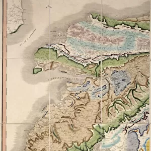
Geological map, South-East England, 1830s
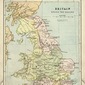
Geological map, South-East England, 1830s. This map, dating from between 1830 and 1833, shows the denudation of The Weald. It was published in Principles of Geology by the British geologist Charles Lyell (1797-1875)
Science Photo Library features Science and Medical images including photos and illustrations
Media ID 6332215
© SCIENCE, INDUSTRY AND BUSINESS LIBRARY/NEW YORK PUBLIC LIBRARY/SCIENCE PHOTO LIBRARY
1830s Chart Deforestation Diagram Earth Science Geological Highlands Charles Lyell Denudation The Weald Weald
FEATURES IN THESE COLLECTIONS
> Europe
> Related Images
> Europe
> United Kingdom
> England
> Maps
> Europe
> United Kingdom
> England
> York
> Europe
> United Kingdom
> Maps
> Europe
> United Kingdom
> Related Images
> Europe
> United Kingdom
> Scotland
> Highlands
> Related Images
> Maps and Charts
> Early Maps
> Maps and Charts
> Geological Map
> Maps and Charts
> Related Images
> North America
> United States of America
> New York
> New York
> Maps
EDITORS COMMENTS
This print showcases a remarkable geological map of South-East England, dating back to the 1830s. Created by the renowned British geologist Charles Lyell, this intricate illustration provides valuable insights into the denudation of The Weald during that era. Published in his influential book Principles of Geology, this map stands as a testament to Lyell's significant contributions to earth science. The map itself is a true work of art, meticulously crafted with precise detail and accuracy. Its purpose was not only to document the geographical features but also shed light on historical and environmental aspects. With its rich hues and intricate lines, it transports us back in time to witness the landscape transformations that occurred in this region during the early 19th century. One cannot help but marvel at how deforestation has shaped The Weald over time. This visual representation highlights both natural processes and human impact on these chalk uplands. As we delve into its depths, we uncover layers of history embedded within each contour line. As an invaluable piece of scientific heritage, this geological map serves as a reminder of our ever-evolving understanding of Earth's complex systems. It symbolizes Charles Lyell's dedication to unraveling nature's mysteries while leaving an indelible mark on British geology and beyond.
MADE IN THE USA
Safe Shipping with 30 Day Money Back Guarantee
FREE PERSONALISATION*
We are proud to offer a range of customisation features including Personalised Captions, Color Filters and Picture Zoom Tools
SECURE PAYMENTS
We happily accept a wide range of payment options so you can pay for the things you need in the way that is most convenient for you
* Options may vary by product and licensing agreement. Zoomed Pictures can be adjusted in the Cart.