Home > Europe > France > Canton > Landes
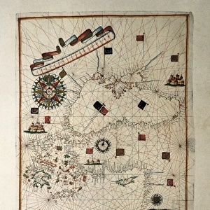
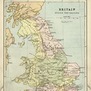
Spanish map of England, Scotland and Ireland

![]()
Wall Art and Photo Gifts from Mary Evans Picture Library
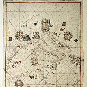
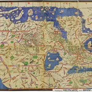
Spanish map of England, Scotland and Ireland
A Spanish map of England, Scotland and Ireland and the coast of northern France from the time of the Anglo Spanish War. Joan Martines (1556-1591). Date: 1587
Mary Evans Picture Library makes available wonderful images created for people to enjoy over the centuries
Media ID 8262607
© Mary Evans Picture Library 2015 - https://copyrighthub.org/s0/hub1/creation/maryevans/MaryEvansPictureID/10410063
Document Joan Martines Nautical Navigation Portolan Scot Land
FEATURES IN THESE COLLECTIONS
> Europe
> France
> Canton
> Landes
> Europe
> Republic of Ireland
> Maps
> Europe
> Spain
> Related Images
> Europe
> United Kingdom
> England
> Maps
> Europe
> United Kingdom
> England
> Posters
> Europe
> United Kingdom
> England
> Related Images
EDITORS COMMENTS
This intriguing map print, titled "Nueva Carta de Inglaterra, Escocia, y Hibernia, con parte de Galia," is a rare and captivating representation of the British Isles and the northern coast of France as depicted in a Spanish map from the time of the Anglo-Spanish War. Dated 1587, the map was created by the cartographer Joan Martines, who meticulously documented the coastlines and geographical features of the region with remarkable detail and accuracy. The map is a testament to the rich history of maritime exploration and the complex political landscape of the late 16th century. At the time, Spain and England were engaged in a protracted conflict, with England seeking to assert its dominance in the New World and Spain determined to protect its colonial territories. This map reflects the strategic importance of the waters surrounding the British Isles and northern France, which were crucial for the movement of troops and supplies between the various European powers. The map is also an excellent example of the portolan chart tradition, which originated in the Mediterranean and was characterized by its use of rhumb lines and detailed depictions of coastlines. The map's vibrant colors and ornate cartouche further enhance its visual appeal and historical significance. Despite the map's Spanish origin, it offers valuable insights into the geographical knowledge of the period, as well as the cartographic techniques and artistic styles employed by European mapmakers during the Age of Discovery. This fascinating document is a must-have for scholars of history, cartography, and maritime exploration, as well as anyone interested in the rich and complex history of the British Isles and Europe during the late 16th century.
MADE IN THE USA
Safe Shipping with 30 Day Money Back Guarantee
FREE PERSONALISATION*
We are proud to offer a range of customisation features including Personalised Captions, Color Filters and Picture Zoom Tools
SECURE PAYMENTS
We happily accept a wide range of payment options so you can pay for the things you need in the way that is most convenient for you
* Options may vary by product and licensing agreement. Zoomed Pictures can be adjusted in the Cart.