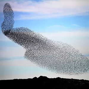
Home > Animals > Birds > Passerines > Starlings > Common Starling
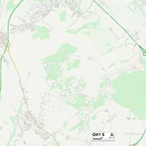
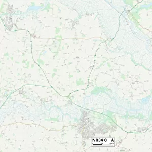
Norfolk NR9 5 Map

![]()
Wall Art and Photo Gifts from Map Marketing
Norfolk NR9 5 Map
Postcode Sector Map of Norfolk NR9 5
Media ID 19976280
Back Lane Barford Road Berrys Lane Blackwater Blind Lane Breck Road Broad Lane Broom Lane Buxton Close Cardinal Close Church Farm Close Church Farm Lane Church Field Church Lane Church Road Common Lane Cotton Road Dereham Road Dog Lane Easton Enterprise Way Fakenham Road Grange Lane Grove Lane Hall Drive Hall Road Heath Close Heath Lane Heath Road Home Close Kennedy Close Lake View Close Lime Kiln Road Mill Lane Mill Road Morton Morton Lane Norfolk Norwich Road Oakwood Close Pack Lane Parkers Close Peacock Close Porters Lane Post Office Lane Quarry Lane Rabbit Lane Rectory Road Reepham Road Richmond Close Richmond Place Sandy Lane School Road Springwell Lane St Peters Drive Station Road Swan Close The Broadway The Common The Drift The Street Well Close Well Lane Weston Road Whitwell Road Wood Lane Woodview Road Colton Hall Walk Pockthorpe Swannington
FEATURES IN THESE COLLECTIONS
> Animals
> Birds
> Passerines
> Starlings
> Common Starling
> Animals
> Birds
> Passerines
> Starlings
> Related Images
> Animals
> Mammals
> Muridae
> Heath Mouse
> Animals
> Mammals
> Muridae
> Little Wood Mouse
> Animals
> Mammals
> Muridae
> Peters Mouse
> Arts
> Artists
> F
> John Field
> Arts
> Artists
> H
> John Hillers
> Arts
> Artists
> H
> John Hills
> Arts
> Artists
> P
> John Parker
> Arts
> Artists
> W
> John Wood
> Map Marketing
> Postcode Sector Maps
> NR - Norwich
MADE IN THE USA
Safe Shipping with 30 Day Money Back Guarantee
FREE PERSONALISATION*
We are proud to offer a range of customisation features including Personalised Captions, Color Filters and Picture Zoom Tools
SECURE PAYMENTS
We happily accept a wide range of payment options so you can pay for the things you need in the way that is most convenient for you
* Options may vary by product and licensing agreement. Zoomed Pictures can be adjusted in the Cart.