Home > Arts > Street art graffiti > Digital art > Vector illustrations
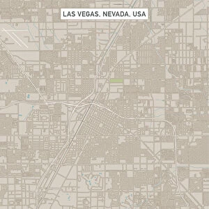
North Las Vegas Nevada US City Street Map

![]()
Wall Art and Photo Gifts from Fine Art Storehouse
North Las Vegas Nevada US City Street Map
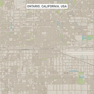
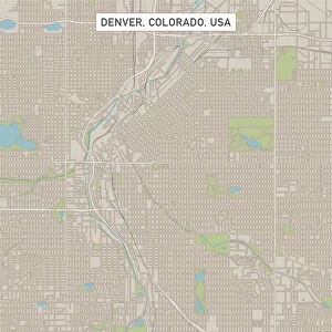
Vector Illustration of a City Street Map of North Las Vegas, Nevada, USA. Scale 1:60, 000.
All source data is in the public domain.
U.S. Geological Survey, US Topo
Used Layers:
USGS The National Map: National Hydrography Dataset (NHD)
USGS The National Map: National Transportation Dataset (NTD)
Unleash your creativity and transform your space into a visual masterpiece!
Frank Ramspott
Media ID 15215862
© Frank Ramspott, all rights reserved
Aerial View City Map Computer Graphic Directly Above Downtown District Gray Las Vegas Nevada Road Map Text Digitally Generated Image White Color
FEATURES IN THESE COLLECTIONS
> Aerial Photography
> Related Images
> Arts
> Contemporary art
> Digital artwork
> Street art
> Arts
> Landscape paintings
> Waterfall and river artworks
> River artworks
> Arts
> Portraits
> Pop art gallery
> Street art portraits
> Arts
> Street art graffiti
> Digital art
> Digital paintings
> Arts
> Street art graffiti
> Digital art
> Vector illustrations
> Fine Art Storehouse
> Map
> Street Maps
> Fine Art Storehouse
> Map
> USA Maps
> Maps and Charts
> Geological Map
> Maps and Charts
> Related Images
> North America
> United States of America
> Lakes
> Related Images
> North America
> United States of America
> Maps
EDITORS COMMENTS
This print showcases a detailed and intricate city street map of North Las Vegas, Nevada, USA. With a scale of 1:60,000, every nook and cranny of this bustling city is beautifully illustrated in vector format. The source data used to create this masterpiece is all in the public domain, courtesy of the U. S. Geological Survey's National Map. The various layers utilized in this artwork include the National Hydrography Dataset (NHD) and the National Transportation Dataset (NTD), both provided by USGS. These layers contribute to an accurate representation of not only streets but also lakes, rivers, and other geographical features that shape North Las Vegas. In this digitally generated image captured from an aerial view directly above the cityscape, one can appreciate the meticulous cartography and design work involved. The absence of people allows for a clear focus on the vibrant colors employed - shades of gray representing roads contrasted with blue bodies of water against a white background. This print by Frank Ramspott serves as more than just a decorative piece; it offers insight into North Las Vegas' urban layout while highlighting its downtown district. Whether you're exploring or simply appreciating fine art, this visually striking map will undoubtedly captivate your imagination with its attention to detail and precision.
MADE IN THE USA
Safe Shipping with 30 Day Money Back Guarantee
FREE PERSONALISATION*
We are proud to offer a range of customisation features including Personalised Captions, Color Filters and Picture Zoom Tools
SECURE PAYMENTS
We happily accept a wide range of payment options so you can pay for the things you need in the way that is most convenient for you
* Options may vary by product and licensing agreement. Zoomed Pictures can be adjusted in the Cart.