Home > Arts > Street art graffiti > Digital art > Vector illustrations
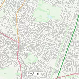
McAllen Texas US City Street Map

![]()
Wall Art and Photo Gifts from Fine Art Storehouse
McAllen Texas US City Street Map
Vector Illustration of a City Street Map of McAllen, Texas, USA. Scale 1:60, 000.
All source data is in the public domain.
U.S. Geological Survey, US Topo
Used Layers:
USGS The National Map: National Hydrography Dataset (NHD)
USGS The National Map: National Transportation Dataset (NTD)
Unleash your creativity and transform your space into a visual masterpiece!
Frank Ramspott
Media ID 15192966
© Frank Ramspott, all rights reserved
Aerial View City Map Computer Graphic Directly Above Downtown District Gray Road Map Texas Text Digitally Generated Image Green Color Mcallen White Color
FEATURES IN THESE COLLECTIONS
> Aerial Photography
> Related Images
> Animals
> Insects
> Hemiptera
> Green Scale
> Arts
> Contemporary art
> Digital artwork
> Street art
> Arts
> Landscape paintings
> Waterfall and river artworks
> River artworks
> Arts
> Portraits
> Pop art gallery
> Street art portraits
> Arts
> Street art graffiti
> Digital art
> Digital paintings
> Arts
> Street art graffiti
> Digital art
> Vector illustrations
> Fine Art Storehouse
> Map
> Street Maps
> Fine Art Storehouse
> Map
> USA Maps
> Maps and Charts
> Geological Map
> Maps and Charts
> Related Images
> North America
> United States of America
> Lakes
> Related Images
EDITORS COMMENTS
This print showcases a detailed and visually stunning city street map of McAllen, Texas, USA. With a scale of 1:60,000, every intricate detail is brought to life in this vector illustration. The artist, Frank Ramspott, has expertly utilized various layers from the public domain sources such as USGS The National Map: National Hydrography Dataset (NHD) and USGS The National Map: National Transportation Dataset (NTD), ensuring accuracy and authenticity. The image captures the essence of McAllen's downtown district with its bustling streets and vibrant atmosphere. A serene lake peacefully flows through the city while a majestic river adds to its natural beauty. Every road is meticulously depicted on this comprehensive road map that serves as an invaluable guide for both residents and visitors alike. Ramspott's digital rendering skillfully combines elements of cartography and design to create a visually striking aerial view directly above McAllen. Shades of gray, blue, white, and green dominate the color palette, adding depth to the composition. This digitally generated image is devoid of people but brims with life through its rich depiction of physical geography. It serves as a testament to Ramspott's artistic prowess in creating captivating computer graphics that seamlessly blend artistry with functionality. A true masterpiece in itself, this print by Frank Ramspott offers viewers an opportunity to explore McAllen's urban landscape from the comfort of their own homes or offices.
MADE IN THE USA
Safe Shipping with 30 Day Money Back Guarantee
FREE PERSONALISATION*
We are proud to offer a range of customisation features including Personalised Captions, Color Filters and Picture Zoom Tools
SECURE PAYMENTS
We happily accept a wide range of payment options so you can pay for the things you need in the way that is most convenient for you
* Options may vary by product and licensing agreement. Zoomed Pictures can be adjusted in the Cart.