Home > Animals > Insects > Hemiptera > Rose Scale
Passport map Wadden Sea Den Helder Terschelling New Pascaert

![]()
Wall Art and Photo Gifts from Liszt Collection
Passport map Wadden Sea Den Helder Terschelling New Pascaert
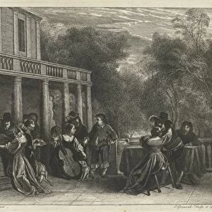
Passport map of the Wadden Sea from Den Helder to Terschelling New Pascaert Where to insert the holes of Texel and T Vlie With all syn Mercken and, depth and drought everything on t Nieuws Oversien and corrected of many errors (title on object), Passport of the Wadden Sea from Den Helder to Terschelling, with two compass roses, the North is below. Bottom right a cartouche with the title and address of the publisher, with some sailors with instruments and a dog. Under the title, the scale in German, Spanish and English or French miles, seaman, dog, maps, atlases, minerals and metals: lead, Wadden Sea, Texel, Vlieland, Terschelling, Den Helder, Wieringen, Jan Luyken, Amsterdam, 1681 - 1799, paper, engraving, h 513 mm × w 581 mm
Liszt Collection of nineteenth-century engravings and images to browse and enjoy
Media ID 19538826
© Artokoloro
1681 1799 Address Atlases Bottom Right Cartouche Corrected Depth French Miles Holes Instruments Jan Luyken Lead Maps North Passport Map Sailors Scale Seaman Spanish Texel Title Two Compass Roses Under Vlieland Wadden Sea Den Helder Errors Insert Metals Minerals Passport Publisher Terschelling Wieringen
FEATURES IN THESE COLLECTIONS
> Animals
> Insects
> Hemiptera
> Rose Scale
> Arts
> Artists
> L
> Jan Luyken
> Europe
> Germany
> Heritage Sites
> Wadden Sea
> Maps and Charts
> Related Images
> Maps and Charts
> Spain
EDITORS COMMENTS
This print showcases a historic passport map of the Wadden Sea, stretching from Den Helder to Terschelling. The intricate details on this map are truly remarkable, providing valuable information for sailors and seamen navigating these treacherous waters. The map features two compass roses, with the North positioned below for easy orientation. At the bottom right corner, a beautifully designed cartouche displays the title and address of the publisher. Adding charm to this scene are a group of sailors accompanied by their trusty dog, engrossed in their instruments. One cannot miss the meticulous attention given to accuracy and precision on this passport map. It includes essential elements such as depth measurements and drought levels, ensuring safe passage through Texel and T Vlie - both marked with strategically placed holes. Underneath the title lies an informative scale presented in German, Spanish, English or French miles - catering to international seafarers who relied on these maps during their voyages. Created between 1681-1799 by Jan Luyken in Amsterdam, this paper engraving measures an impressive 513mm in height and 581mm in width. Its historical significance is further enhanced by its association with minerals like lead found within its composition. Overall, this passport map serves as a testament to both artistic craftsmanship and navigational expertise of centuries past – offering us a glimpse into maritime history that continues to fascinate today.
MADE IN THE USA
Safe Shipping with 30 Day Money Back Guarantee
FREE PERSONALISATION*
We are proud to offer a range of customisation features including Personalised Captions, Color Filters and Picture Zoom Tools
SECURE PAYMENTS
We happily accept a wide range of payment options so you can pay for the things you need in the way that is most convenient for you
* Options may vary by product and licensing agreement. Zoomed Pictures can be adjusted in the Cart.