Home > Europe > United Kingdom > England > London > Museums > British Museum
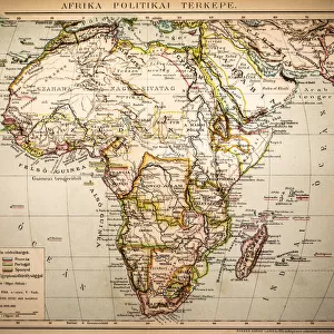
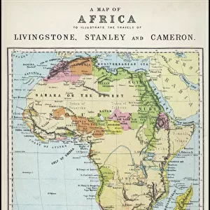
Map of Africa showing Treaty Boundaries, 1891 (colour lithograph)
")
![]()
Wall Art and Photo Gifts from Fine Art Finder
Map of Africa showing Treaty Boundaries, 1891 (colour lithograph)
XCF282018 Map of Africa showing Treaty Boundaries, 1891 (colour lithograph) by English School, (19th century); British Museum, London, UK; English, out of copyright
Media ID 12795144
© www.bridgemanart.com
Atlantic Ocean Boundary Colonies Continent Countries Equator Frontier Madagascar Pacific Ocean Surveying Political Map
FEATURES IN THESE COLLECTIONS
> Africa
> Madagascar
> Maps
> Africa
> Madagascar
> Related Images
> Africa
> Related Images
> Arts
> Artists
> O
> Oceanic Oceanic
> Europe
> United Kingdom
> England
> London
> Museums
> British Museum
> Europe
> United Kingdom
> England
> London
> Politics
> Related Images
> Europe
> United Kingdom
> England
> London
> Related Images
> Europe
> United Kingdom
> England
> London
> Sights
> British Museum
> Europe
> United Kingdom
> Maps
> Fine Art Finder
> Schools
> English School
EDITORS COMMENTS
This print titled "Map of Africa showing Treaty Boundaries, 1891" takes us back to a significant moment in history. The vibrant colours and intricate details of this colour lithograph bring the continent's political landscape to life. Created by an anonymous English School artist from the 19th century, this piece is now housed in the prestigious British Museum in London. The map showcases the colonial era, with its focus on geography, cartography, and empire-building. It highlights various countries and their boundaries as determined by treaties during that time period. Surveying techniques were employed to accurately depict frontier lines and borders across Africa. As we gaze upon this artwork, we are reminded of the vastness of Africa - stretching from the Atlantic Ocean to the Pacific Ocean - with Madagascar standing out prominently off its eastern coast. The equator runs through several African nations, adding another layer of geographical significance. This historical map serves as a visual representation of how power dynamics played out during European colonization efforts in Africa. It offers valuable insights into both past political realities and contemporary discussions surrounding decolonization movements. Through this lens, "Map of Africa showing Treaty Boundaries" invites viewers to reflect on our shared global history while also acknowledging ongoing conversations about identity, sovereignty, and territorial disputes within African nations today.
MADE IN THE USA
Safe Shipping with 30 Day Money Back Guarantee
FREE PERSONALISATION*
We are proud to offer a range of customisation features including Personalised Captions, Color Filters and Picture Zoom Tools
SECURE PAYMENTS
We happily accept a wide range of payment options so you can pay for the things you need in the way that is most convenient for you
* Options may vary by product and licensing agreement. Zoomed Pictures can be adjusted in the Cart.