Home > Arts > Artists > A > Battista Agnese
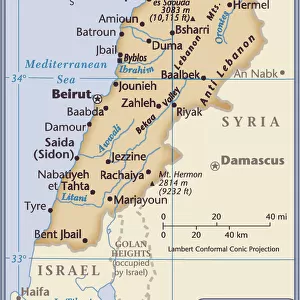
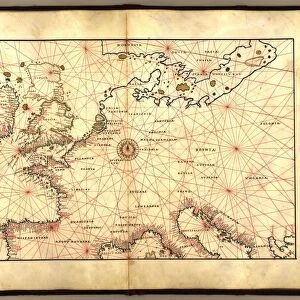
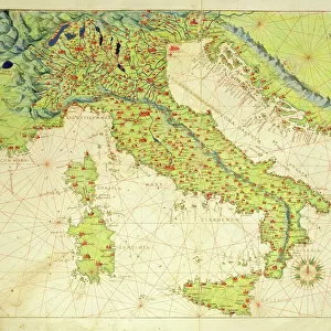
Map of Das Heilige Land 1554 [Translation: The Holy land], 1554 (vellum)
![Map of Das Heilige Land 1554 [Translation: The Holy land], 1554 (vellum)](/p/690/map-das-heilige-land-1554-translation-38509994.jpg.webp "Map of Das Heilige Land 1554 [Translation: The Holy land], 1554 (vellum)")
![]()
Wall Art and Photo Gifts from Fine Art Finder
Map of Das Heilige Land 1554 [Translation: The Holy land], 1554 (vellum)
7339649 Map of Das Heilige Land 1554 [Translation: The Holy land], 1554 (vellum) by Agnese, Battista (c.1500-64); 26x40 cm; National Maritime Museum, London, UK; (add.info.: Creator: Battista Agnese
Bound sheet. Scale: [circa 1:1 400 000 (scale)]. Cartographic Note: North at 270 degrees. Additional Places: Syria, Lebanon, Israel. Contents Note: Iconography: winds; cities, towns and castles; one ship. Bound in an atlas of twenty-four cartographic items titled: Seekarten von Battista Agnese Anno MDLIV.d.IV.May. The atlas also includes astronomical tables and diagrams. Text in Latin, titles and place names in German outside borders.); © National Maritime Museum, Greenwich, London
Media ID 38509994
© © National Maritime Museum, Greenwich, London / Bridgeman Images
Israel Israel Israeli Israeli Lebanese Lebanon Lebanon Lebanese Libanese Palestine Palestine Palestinian Palestinian Palestinians Syria Syrian Syrians Arab Civilization Arab Culture Arabians C16h
FEATURES IN THESE COLLECTIONS
> Arts
> Artists
> A
> Battista Agnese
> Arts
> Artists
> S
> Syrian Syrian
> Asia
> Israel
> Related Images
> Asia
> Lebanon
> Related Images
> Asia
> Palestine
> Related Images
> Asia
> Syria
> Related Images
> Fine Art Finder
> Artists
> Battista Agnese
EDITORS COMMENTS
This stunning print captures a piece of history with the Map of 'Das Heilige Land' from 1554, created by Battista Agnese. The intricate details and vibrant colors bring to life this cartographic masterpiece, showcasing the Holy Land in all its glory.
Measuring 26x40 cm on vellum, this map is part of an atlas containing twenty-four cartographic items titled 'Seekarten von Battista Agnese Anno MDLIV.d.IV.May.' The map features iconography such as winds, cities, towns, castles, and even a ship. With North at 270 degrees, it covers areas including Syria, Lebanon, and Israel.
The text is in Latin with titles and place names in German outside borders. This historical artifact provides a glimpse into the past with its detailed representation of the Middle East during the sixteenth century. It serves as a valuable resource for understanding the geography and culture of the region at that time.
Displayed at the National Maritime Museum in London, UK, this print preserves the beauty and significance of Battista Agnese's work for future generations to admire and study. It stands as a testament to his skill as a cartographer and his contribution to our understanding of ancient civilizations like Arab culture in Palestine.
MADE IN THE USA
Safe Shipping with 30 Day Money Back Guarantee
FREE PERSONALISATION*
We are proud to offer a range of customisation features including Personalised Captions, Color Filters and Picture Zoom Tools
SECURE PAYMENTS
We happily accept a wide range of payment options so you can pay for the things you need in the way that is most convenient for you
* Options may vary by product and licensing agreement. Zoomed Pictures can be adjusted in the Cart.