Home > Europe > United Kingdom > Scotland > West Lothian > Armadale
Hammersmith and Fulham SW6 1 Map

![]()
Wall Art and Photo Gifts from Map Marketing
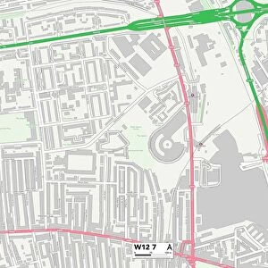
Hammersmith and Fulham SW6 1 Map
Postcode Sector Map of Hammersmith and Fulham SW6 1
Media ID 19978558
Armadale Road Barclay Road Chestnut Court Farm Lane Halford Road Hammersmith And Fulham Hilary Close North End Road Ongar Road Peel Place Seagrave Road Tamworth Street
FEATURES IN THESE COLLECTIONS
> Europe
> United Kingdom
> Scotland
> West Lothian
> Armadale
> Map Marketing
> Postcode Sector Maps
> SW - London SW
MADE IN THE USA
Safe Shipping with 30 Day Money Back Guarantee
FREE PERSONALISATION*
We are proud to offer a range of customisation features including Personalised Captions, Color Filters and Picture Zoom Tools
SECURE PAYMENTS
We happily accept a wide range of payment options so you can pay for the things you need in the way that is most convenient for you
* Options may vary by product and licensing agreement. Zoomed Pictures can be adjusted in the Cart.