Home > Europe > United Kingdom > England > London > Art > Theatre
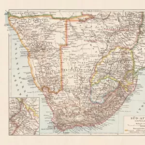
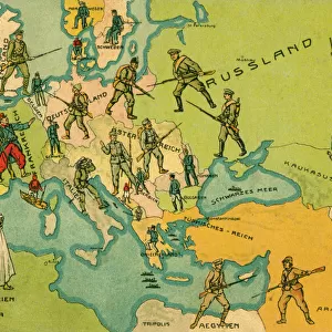
Map of German South West Africa, First World War, (c1920). Creator: John Bartholomew & Son
. Creator: John Bartholomew & Son")
![]()
Wall Art and Photo Gifts from Heritage Images
Map of German South West Africa, First World War, (c1920). Creator: John Bartholomew & Son
Map of German South West Africa, First World War, (c1920). The German annexation of South West Africa took place in the 1880s. After 106 years of German and South African rule, Namibia became independent in 1990. From " The Great World War - A History" Volume III, edited by Frank A Mumby. [The Gresham Publishing Company Ltd, London, c1920]
Heritage Images features heritage image collections
Media ID 19175441
© The Print Collector/Heritage Images
Bartholomew Bartholomew And Co Bartholomew Co Bartholomew John Son Frank Arthur Frank Arthur Mumby German Empire Gresham Publishing Co Ltd Gresham Publishing Company Jg Bartholomew John And Son John Bartholomew And Co John Bartholomew And Son John Bartholomew And Son Ltd John Bartholomew Co John Bartholomew Son John Bartholomew Son Ltd John Son Keystone Archives Mumby Mumby Frank Arthur Namibia Namibia Africa Occupied Territory Territorial Territory The Great World War A History Theatre Of War South West Africa
FEATURES IN THESE COLLECTIONS
> Africa
> Namibia
> Related Images
> Africa
> South Africa
> Maps
> Africa
> South Africa
> Related Images
> Europe
> United Kingdom
> England
> London
> Art
> Theatre
> Historic
> Colonial history
> Colonial art and artists
> Historic
> World War I and II
> World War I
> Historic
> World War I and II
EDITORS COMMENTS
This print showcases a historical map of German South West Africa during the First World War, dating back to approximately 1920. Created by John Bartholomew & Son, this map sheds light on the German annexation of South West Africa in the 1880s and its subsequent rule for over a century. Namibia's journey towards independence finally culminated in 1990 after enduring both German and South African governance. Extracted from "The Great World War - A History". Volume III, edited by Frank A Mumby, this image offers a glimpse into an era defined by colonialism and territorial disputes. The vibrant colors employed in this map bring life to the concept of empire-building as well as highlighting key locations along the coastal region. As we delve into this piece of history, it becomes evident that it serves not only as a geographical representation but also as a testament to the significant role played by Germany during World War I. This print is truly an invaluable resource for those seeking to understand the complexities surrounding Namibia's occupation and its place within the theatre of war. Preserved through time by Heritage Images, this remarkable artifact provides us with valuable insights into past events while reminding us of our collective responsibility to learn from history's triumphs and mistakes alike.
MADE IN THE USA
Safe Shipping with 30 Day Money Back Guarantee
FREE PERSONALISATION*
We are proud to offer a range of customisation features including Personalised Captions, Color Filters and Picture Zoom Tools
SECURE PAYMENTS
We happily accept a wide range of payment options so you can pay for the things you need in the way that is most convenient for you
* Options may vary by product and licensing agreement. Zoomed Pictures can be adjusted in the Cart.