Home > Europe > United Kingdom > England > East Sussex > Hastings
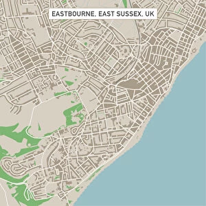
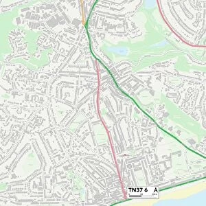
Hastings East Sussex UK City Street Map

![]()
Wall Art and Photo Gifts from Fine Art Storehouse
Hastings East Sussex UK City Street Map
Vector Illustration of a City Street Map of Hastings, East Sussex, UK. Included files are EPS (v10) and Hi-Res JPG.
Data courtesy from Ordnance Survey: VectorMap District
https:/ordnancesurvey.co.uk/business-and-government/products/vectormap-district.html
OS OpenData is free to use under the Open Government Licence (OGL).
Contains OS data eCrown copyright and database right 2017.
http:/nationalarchives.gov.uk/doc/open-government-licence/version/3/
Unleash your creativity and transform your space into a visual masterpiece!
Frank Ramspott
Media ID 15055215
© Frank Ramspott, all rights reserved
Aerial View Computer Graphic Directly Above East Sussex English Channel Gray Green Harbor Hastings North Sea Road Map Street Map Text Digitally Generated Image
FEATURES IN THESE COLLECTIONS
> Aerial Photography
> Related Images
> Arts
> Contemporary art
> Digital artwork
> Street art
> Arts
> Portraits
> Pop art gallery
> Street art portraits
> Arts
> Street art graffiti
> Digital art
> Digital paintings
> Arts
> Street art graffiti
> Digital art
> Vector illustrations
> Europe
> United Kingdom
> England
> East Sussex
> Hastings
> Europe
> United Kingdom
> England
> East Sussex
> Related Images
> Europe
> United Kingdom
> England
> Sussex
> Hastings
> Europe
> United Kingdom
> England
> Sussex
> Related Images
> Europe
> United Kingdom
> Maps
> Fine Art Storehouse
> Map
> Street Maps
EDITORS COMMENTS
This print showcases a meticulously detailed vector illustration of the charming city street map of Hastings, East Sussex in the United Kingdom. The artist, Frank Ramspott, has expertly crafted this digitally generated image that highlights every intricate detail of the town's layout. The map includes essential features such as roads, buildings, and streets with precision and accuracy. With its vibrant colors - shades of gray, green, blue, and white - it beautifully captures the essence of this coastal city nestled between the North Sea and English Channel. The inspiration for this artwork stems from Ordnance Survey's VectorMap District data courtesy. It is worth noting that OS OpenData allows free usage under the Open Government Licence (OGL), while acknowledging OS data eCrown copyright and database right 2017. This aerial view perspective offers a unique glimpse into Hastings' physical geography while omitting any human presence to focus solely on its urban landscape. Whether you are an avid cartography enthusiast or simply appreciate stunning design elements, this print will undoubtedly captivate your attention. Perfect for home decor or office spaces alike, this high-resolution JPG file can be easily printed to adorn your walls with a piece that celebrates both artistry and geographical exploration.
MADE IN THE USA
Safe Shipping with 30 Day Money Back Guarantee
FREE PERSONALISATION*
We are proud to offer a range of customisation features including Personalised Captions, Color Filters and Picture Zoom Tools
SECURE PAYMENTS
We happily accept a wide range of payment options so you can pay for the things you need in the way that is most convenient for you
* Options may vary by product and licensing agreement. Zoomed Pictures can be adjusted in the Cart.