Home > Europe > United Kingdom > England > Kingston upon Hull
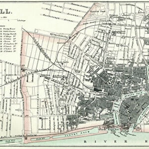
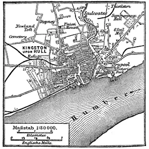
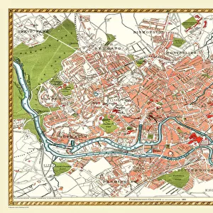
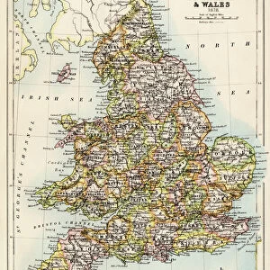
Old Map of Kingston Upon Hull 1862 by Fullarton & Co

![]()
Wall Art and Photo Gifts from MapSeeker
Old Map of Kingston Upon Hull 1862 by Fullarton & Co
This is an interesting and detailed reproduction Victorian town plan of Kingston-upon-Hull which was originally published in John Marius Wilsons The Imperial Gazeteer of England and Wales (A.Fullarton & co. 1865-1874)
Welcome to the Mapseeker Image library and enter an historic gateway to one of the largest on-line collections of Historic Maps, Nostalgic Views, Vista's and Panorama's from a World gone by.
Media ID 20347094
Historic Map Old Town Plan Hull Hull City Kingston Upon Hull
FEATURES IN THESE COLLECTIONS
> Arts
> Artists
> W
> Wilson Wilson
> Arts
> Photorealistic artworks
> Detailed art pieces
> Masterful detailing in art
> Europe
> United Kingdom
> England
> Kingston upon Hull
> Europe
> United Kingdom
> England
> Maps
> Europe
> United Kingdom
> Wales
> Maps
> Europe
> United Kingdom
> Wales
> Posters
> Europe
> United Kingdom
> Wales
> Related Images
> Maps and Charts
> Related Images
> Maps and Charts
> Wales
> MapSeeker
> British Town And City Plans
> English & Welsh PORTFOLIO
EDITORS COMMENTS
This print showcases an exquisite reproduction of the "Old Map of Kingston Upon Hull 1862" by Fullarton & Co. Stepping back in time, this Victorian town plan offers a fascinating glimpse into the historical layout and intricate details of Kingston-upon-Hull. Originally published in John Marius Wilson's renowned work, The Imperial Gazetteer of England and Wales (A. Fullarton & co. 1865-1874), this map has been meticulously reproduced to preserve its authenticity. The map itself is a treasure trove for history enthusiasts, cartographers, and anyone with an interest in Hull's past. With its delicate lines and ornate typography, it presents a comprehensive view of the city during that era. Every street, building, park, and waterway is intricately depicted on this remarkable piece. As we explore this old town plan, we are reminded of how much Hull has evolved over time while still retaining its unique charm. This historic map serves as a testament to the rich heritage that shaped the city into what it is today. Whether you're a resident seeking to connect with your roots or simply captivated by historical maps, this print will transport you back to Victorian times. It allows us to appreciate not only the craftsmanship involved but also gain insights into how our beloved city has transformed throughout history
MADE IN THE USA
Safe Shipping with 30 Day Money Back Guarantee
FREE PERSONALISATION*
We are proud to offer a range of customisation features including Personalised Captions, Color Filters and Picture Zoom Tools
SECURE PAYMENTS
We happily accept a wide range of payment options so you can pay for the things you need in the way that is most convenient for you
* Options may vary by product and licensing agreement. Zoomed Pictures can be adjusted in the Cart.