Home > Aerial Photography > Related Images
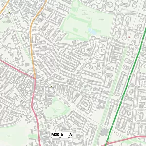
Tulsa Oklahoma US City Street Map

![]()
Wall Art and Photo Gifts from Fine Art Storehouse
Tulsa Oklahoma US City Street Map
Vector Illustration of a City Street Map of Tulsa, Oklahoma, USA. Scale 1:60, 000.
All source data is in the public domain.
U.S. Geological Survey, US Topo
Used Layers:
USGS The National Map: National Hydrography Dataset (NHD)
USGS The National Map: National Transportation Dataset (NTD)
Unleash your creativity and transform your space into a visual masterpiece!
Frank Ramspott
Media ID 15215772
© Frank Ramspott, all rights reserved
Aerial View City Map Computer Graphic Directly Above Downtown District Gray Oklahoma Road Map Text Digitally Generated Image Green Color Tulsa White Color
FEATURES IN THESE COLLECTIONS
> Aerial Photography
> Related Images
> Animals
> Insects
> Hemiptera
> Green Scale
> Arts
> Contemporary art
> Digital artwork
> Street art
> Arts
> Landscape paintings
> Waterfall and river artworks
> River artworks
> Arts
> Portraits
> Pop art gallery
> Street art portraits
> Arts
> Street art graffiti
> Digital art
> Digital paintings
> Arts
> Street art graffiti
> Digital art
> Vector illustrations
> Fine Art Storehouse
> Map
> Street Maps
> Fine Art Storehouse
> Map
> USA Maps
> Maps and Charts
> Geological Map
> Maps and Charts
> Related Images
> North America
> United States of America
> Lakes
> Related Images
EDITORS COMMENTS
This print showcases a meticulously detailed vector illustration of Tulsa, Oklahoma's city street map. With a scale of 1:60,000, every intricate aspect of the city is beautifully depicted in this artwork. The artist, Frank Ramspott, has utilized various layers from public domain sources such as the U. S. Geological Survey and US Topo to create this masterpiece. The image encompasses the downtown district of Tulsa along with its mesmerizing lake and river views. Every street and road is intricately designed to provide an accurate representation of the city's layout. The combination of gray, blue, white, and green colors adds depth and vibrancy to the digitally generated image. This aerial view allows viewers to appreciate the physical geography of Tulsa directly from above. The absence of people in the picture emphasizes the focus on cartography and design rather than human activity. Perfect for enthusiasts or residents alike, this print captures not only the essence but also serves as a functional tool for navigation within Tulsa's streetscape. Whether hung on a wall or used as reference material, it offers both aesthetic appeal and practicality
MADE IN THE USA
Safe Shipping with 30 Day Money Back Guarantee
FREE PERSONALISATION*
We are proud to offer a range of customisation features including Personalised Captions, Color Filters and Picture Zoom Tools
SECURE PAYMENTS
We happily accept a wide range of payment options so you can pay for the things you need in the way that is most convenient for you
* Options may vary by product and licensing agreement. Zoomed Pictures can be adjusted in the Cart.