Home > Europe > Italy > Tuscany > Florence
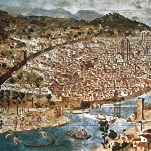
16th Century Plan of Florence

![]()
Wall Art and Photo Gifts from Science Photo Library
16th Century Plan of Florence
16th century plan of Florence, Italy. Detail from the map of Etruria (Tuscany and Northern Lazio), in the Gallery of Maps in the Vatican Museum.The Gallery of Maps holds maps which were commissioned between 1578 and 1580 to show the regions of Italy and territories of the church. The maps are based on the work of Ignazio Danti, a 16th century Italian priest, mathematician, astronomer and cosmographer, and are an important record of 16th century geography. Vatican Museum
Science Photo Library features Science and Medical images including photos and illustrations
Media ID 6321643
© Sheila Terry
1500s 16th Century Atlas Cartography Earth Science Florence Gallery Of Maps Ignazio Danti Italian Italy Mapping Maps Plan Sciences Sixteenth Century Etruria
FEATURES IN THESE COLLECTIONS
> Europe
> Italy
> Lazio
> Related Images
> Europe
> Italy
> Related Images
> Europe
> Italy
> Tuscany
> Florence
> Europe
> Italy
> Tuscany
> Related Images
> Maps and Charts
> Early Maps
> Maps and Charts
> Italy
> Maps and Charts
> Related Images
EDITORS COMMENTS
This print showcases a remarkable 16th-century plan of Florence, Italy. Extracted from the larger map of Etruria (Tuscany and Northern Lazio) housed in the prestigious Gallery of Maps at the Vatican Museum, this detail offers a glimpse into the rich history and geography of Renaissance-era Florence. Commissioned between 1578 and 1580, these maps were created to depict various regions of Italy as well as territories belonging to the Church. The mastermind behind these intricate cartographic works was Ignazio Danti, an esteemed Italian priest, mathematician, astronomer, and cosmographer. His expertise in multiple fields allowed him to craft accurate representations that serve as invaluable records of 16th-century geography. The significance of this particular print lies not only in its historical importance but also in its artistic beauty. The illustration transports viewers back to a time when Florentine culture flourished under Medici patronage and iconic landmarks like Brunelleschi's Dome dominated the cityscape. As we delve into this snapshot from Earth's past, we are reminded of how science intertwines with artistry through cartography. This mesmerizing image invites us to appreciate both the scientific advancements made during the Renaissance period and their visual representation on paper—a testament to human curiosity and ingenuity that continues to inspire us today.
MADE IN THE USA
Safe Shipping with 30 Day Money Back Guarantee
FREE PERSONALISATION*
We are proud to offer a range of customisation features including Personalised Captions, Color Filters and Picture Zoom Tools
SECURE PAYMENTS
We happily accept a wide range of payment options so you can pay for the things you need in the way that is most convenient for you
* Options may vary by product and licensing agreement. Zoomed Pictures can be adjusted in the Cart.