Home > Europe > United Kingdom > Scotland > Highlands > Inverness
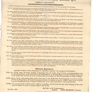
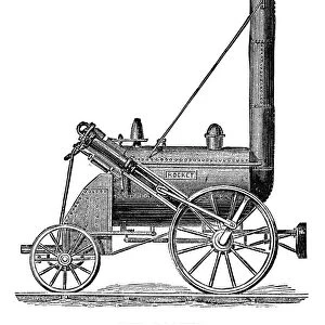
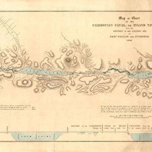
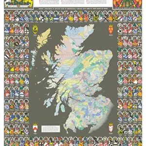
Map or Chart of the Caledonian Canal, or Inland Navigation from the Western to the Eastern Sea by Fort William and Inverness

Wall Art and Photo Gifts from Scottish Canals
Map or Chart of the Caledonian Canal, or Inland Navigation from the Western to the Eastern Sea by Fort William and Inverness
Plan showing the Caledonian Canal from Fort William to Inverness including nearby lochs, rivers and settlements. Ordered by the House of Commons and printed by W. & A. K. Johnston Limited, Edinburgh
Scottish Canals are in charge of the five canals in Scotland
Media ID 14482757
© Scottish Canals
FEATURES IN THESE COLLECTIONS
> Europe
> United Kingdom
> Scotland
> Edinburgh
> Edinburgh
> Europe
> United Kingdom
> Scotland
> Edinburgh
> Europe
> United Kingdom
> Scotland
> Highlands
> Fort William
> Europe
> United Kingdom
> Scotland
> Highlands
> Inverness
> Europe
> United Kingdom
> Scotland
> Inverness
> Europe
> United Kingdom
> Scotland
> Lothian
> Edinburgh
> Europe
> United Kingdom
> Scotland
> Maps
> Europe
> United Kingdom
> Scotland
> Posters
> Europe
> United Kingdom
> Scotland
> Related Images
> Europe
> United Kingdom
> Scotland
> Rivers
> Scottish Canals
> ScottishCanals
EDITORS COMMENTS
This print showcases a historical treasure, the "Map or Chart of the Caledonian Canal, or Inland Navigation from the Western to the Eastern Sea by Fort William and Inverness". Created by A. Stockwell, this plan offers a comprehensive view of the iconic Caledonian Canal route, stretching from Fort William to Inverness in Scotland. With meticulous detail, this map reveals not only the canal itself but also nearby lochs, rivers, and settlements that played an integral role in shaping Scottish history. As we gaze upon this print, our imagination is transported back to a time when trade and transportation relied heavily on these waterways. Commissioned by the House of Commons and printed by W. & A. K. Johnston Limited in Edinburgh, this map serves as both an invaluable historical document and a testament to human ingenuity. It highlights how humans have harnessed nature's resources for their own progress while respecting its beauty. The intricate lines etched on paper depict not just geographical features but also tell stories of perseverance and determination – tales of engineers who overcame immense challenges to construct this remarkable feat of engineering. As we admire this print from Scottish Canals today, let us appreciate those who came before us; their vision has left behind an enduring legacy that continues to shape Scotland's landscape and inspire generations to come.
MADE IN THE USA
Safe Shipping with 30 Day Money Back Guarantee
FREE PERSONALISATION*
We are proud to offer a range of customisation features including Personalised Captions, Color Filters and Picture Zoom Tools
SECURE PAYMENTS
We happily accept a wide range of payment options so you can pay for the things you need in the way that is most convenient for you
* Options may vary by product and licensing agreement. Zoomed Pictures can be adjusted in the Cart.