Home > Arts > Artists > H > Jodocus Hondius
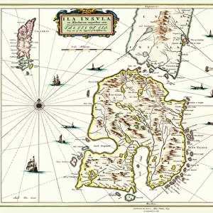
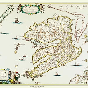
Old Map of The Island of Bermuda 1635 by Willem & Johan Blaue from the Theatrum Orbis Terrarum

![]()
Wall Art and Photo Gifts from MapSeeker
Old Map of The Island of Bermuda 1635 by Willem & Johan Blaue from the Theatrum Orbis Terrarum
This detailed and most attractive reproduction map of The Island of Bermuda has been carefully art worked from a scan of an antique original. The famous firm of Dutch cartographers and publishers was established in the late 16th century by Willem Janszoon Blaeu in Amsterdam. Blaeu was a maker of globes and scientific instruments and purchased some of his early map plates from Jodocus Hondius. From this small beginning was to emerge one of the largest and most prolific map publishing houses of the seventeenth century
Welcome to the Mapseeker Image library and enter an historic gateway to one of the largest on-line collections of Historic Maps, Nostalgic Views, Vista's and Panorama's from a World gone by.
Media ID 20347697
Blaeu Blaeu Family Blaue Map Historic Map Johan Blaeu Johan Blaeu Map Old Blaue Map Bermuda
FEATURES IN THESE COLLECTIONS
> Arts
> Artists
> B
> Willem Blaeu
> Arts
> Artists
> H
> Jodocus Hondius
> Arts
> Photorealistic artworks
> Detailed art pieces
> Masterful detailing in art
> Maps and Charts
> Early Maps
> Maps and Charts
> Related Images
> Maps and Charts
> Willem Janszoon Blaeu
> MapSeeker
> Maps of the Americas
> Maps of Central and South America
> North America
> Bermuda
> Maps
> North America
> Bermuda
> Related Images
EDITORS COMMENTS
This beautifully crafted reproduction of the "Old Map of The Island of Bermuda 1635" by Willem & Johan Blaue takes us back in time to explore the rich history and captivating beauty of this enchanting island. Carefully art worked from a scan of an antique original, this detailed map showcases the expertise and skill of the famous Dutch cartographers and publishers. Established in Amsterdam during the late 16th century by Willem Janszoon Blaeu, who was renowned for his globes and scientific instruments, this iconic firm grew to become one of the largest and most prolific map publishing houses of the seventeenth century. This particular map is a testament to their dedication to accuracy and aesthetics. As we delve into its intricate details, we are transported to a time when Bermuda was known as Isle de Demonstration on maps. From its stunning coastline dotted with coral reefs to its lush interior filled with verdant landscapes, every aspect is meticulously depicted. The historical significance attached to this old Bermuda map adds another layer of fascination. It serves as a window into how early explorers perceived and documented these uncharted territories. Whether you're an avid historian or simply captivated by vintage cartography, this reproduction offers a glimpse into both past eras and distant lands. Display it proudly as a conversation starter or use it as inspiration for your own adventures on the remarkable Island of Bermuda.
MADE IN THE USA
Safe Shipping with 30 Day Money Back Guarantee
FREE PERSONALISATION*
We are proud to offer a range of customisation features including Personalised Captions, Color Filters and Picture Zoom Tools
SECURE PAYMENTS
We happily accept a wide range of payment options so you can pay for the things you need in the way that is most convenient for you
* Options may vary by product and licensing agreement. Zoomed Pictures can be adjusted in the Cart.