Home > Europe > United Kingdom > England > London > Museums > National Maritime Museum
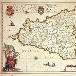
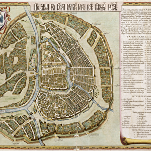
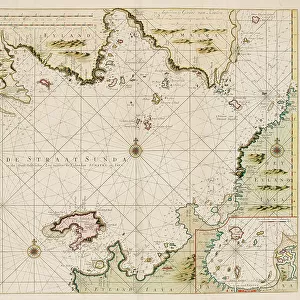
Le grand atlas, ou cosmographie Blauiane, en laquelle est exactement descritte le terre, la mer, et le ciel, vol.I, 1667 (print)
")
![]()
Wall Art and Photo Gifts from Fine Art Finder
Le grand atlas, ou cosmographie Blauiane, en laquelle est exactement descritte le terre, la mer, et le ciel, vol.I, 1667 (print)
7342740 Le grand atlas, ou cosmographie Blauiane, en laquelle est exactement descritte le terre, la mer, et le ciel, vol.I, 1667 (print) by Blaeu, Joan (1596-1673); National Maritime Museum, London, UK; (add.info.: Creator: Joan Blaeu
volume 1. gilt vellum. col maps.); © National Maritime Museum, Greenwich, London
Media ID 38177374
© © National Maritime Museum, Greenwich, London / Bridgeman Images
FEATURES IN THESE COLLECTIONS
> Arts
> Artists
> B
> Joan Blaeu
> Europe
> United Kingdom
> England
> London
> Boroughs
> Greenwich
> Europe
> United Kingdom
> England
> London
> Museums
> Greenwich Heritage Centre
> Europe
> United Kingdom
> England
> London
> Museums
> National Maritime Museum
> Europe
> United Kingdom
> England
> London
> Towns
> Greenwich
> Europe
> United Kingdom
> Heritage Sites
> Maritime Greenwich
> Europe
> United Kingdom
> Maps
> Fine Art Finder
> Artists
> Joan Blaeu
> Fine Art Finder
> Artists
> Johannes II Van Keulen
> Maps and Charts
> Early Maps
> Maps and Charts
> Related Images
> Maps and Charts
> World
EDITORS COMMENTS
This stunning print captures the intricate beauty of Le grand atlas, ou cosmographie Blauiane, a masterpiece created by Joan Blaeu in 1667. The detailed description of the earth, sea, and sky is brought to life through vibrant colors and meticulous cartography.
As you gaze upon this historical artifact, you are transported back to the 17th century when exploration and discovery were at their peak. The gilt vellum cover and colorful maps within volume one of this atlas showcase the skill and artistry of Blaeu's work.
Each map tells a story of distant lands and unknown territories waiting to be explored. The precision with which each detail is depicted highlights the dedication and passion that went into creating this extraordinary piece of cartographic history.
In a time before satellites and GPS technology, maps like these were essential tools for navigating the vast oceans and uncharted lands. They served as guides for sailors seeking new trade routes or adventurers embarking on daring expeditions.
This print from Fine Art Finder allows us to appreciate not only the scientific accuracy but also the artistic beauty of Blaeu's work. It serves as a reminder of our enduring fascination with maps as windows into both our past and future explorations.
MADE IN THE USA
Safe Shipping with 30 Day Money Back Guarantee
FREE PERSONALISATION*
We are proud to offer a range of customisation features including Personalised Captions, Color Filters and Picture Zoom Tools
SECURE PAYMENTS
We happily accept a wide range of payment options so you can pay for the things you need in the way that is most convenient for you
* Options may vary by product and licensing agreement. Zoomed Pictures can be adjusted in the Cart.