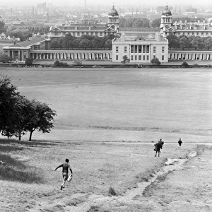
Home > Europe > United Kingdom > England > London > Museums > National Maritime Museum
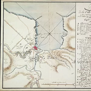
Plan of Jacmel town with fortifications, 1799 (drawing)
")
![]()
Wall Art and Photo Gifts from Fine Art Finder
Plan of Jacmel town with fortifications, 1799 (drawing)
7339492 Plan of Jacmel town with fortifications, 1799 (drawing) by Rivieres, Antoine Francois Sorrel des (1737-1830); 38x53 cm; National Maritime Museum, London, UK; (add.info.: Creator: Sorrel
Original title: Plan de la ville de Jacmel avec ses fortifications leve par le Cen. Sorrel, Ingenieur en chef du Departement de l'Ouest'.
Scale: ca.1:3 500. An ungraduated map with the scale in toises. The map also shows Haiti and there's a street plan with key to public buildings and fortifications.); © National Maritime Museum, Greenwich, London
Media ID 38339612
© © National Maritime Museum, Greenwich, London / Bridgeman Images
Boat Dock Coast Line Harbor Area Harbour Area Harbours Port Area Asiae
FEATURES IN THESE COLLECTIONS
> Asia
> India
> Related Images
> Europe
> United Kingdom
> England
> London
> Boroughs
> Greenwich
> Europe
> United Kingdom
> England
> London
> Museums
> Greenwich Heritage Centre
> Europe
> United Kingdom
> England
> London
> Museums
> National Maritime Museum
> Europe
> United Kingdom
> England
> London
> Towns
> Greenwich
> Europe
> United Kingdom
> Heritage Sites
> Maritime Greenwich
> Europe
> United Kingdom
> Maps
> Fine Art Finder
> Artists
> Antoine François Sorrel des Rivieres
> Fine Art Finder
> Artists
> John (after) Hoppner
> Historic
> Medieval architecture
> Castles and fortresses
> Ancient fortifications
> Maps and Charts
> Early Maps
EDITORS COMMENTS
This stunning print of the Plan of Jacmel town with fortifications, drawn in 1799 by Antoine Francois Sorrel des Rivieres, offers a glimpse into the intricate cartography and strategic planning of the 18th century. The detailed map showcases not only the layout of Jacmel town but also its surrounding fortifications, providing valuable insight into the defensive structures of the time.
Sorrel's expertise as an Ingenieur en chef is evident in this meticulously crafted map, which includes a street plan with key public buildings and fortifications. The scale of ca.1:3 500 allows for a comprehensive view of Haiti and its coastal regions, highlighting the importance of maritime trade and defense during this period.
The vibrant colors used in this drawing bring to life the bustling port city of Jacmel, with boats docked along the shore and bustling activity within its walls. This artwork serves as both a historical document and a work of art, showcasing Sorrel's skill as a cartographer and artist.
As we gaze upon this piece from the National Maritime Museum in London, we are transported back in time to an era where maps were not just navigational tools but works of art that captured the essence of a place.
MADE IN THE USA
Safe Shipping with 30 Day Money Back Guarantee
FREE PERSONALISATION*
We are proud to offer a range of customisation features including Personalised Captions, Color Filters and Picture Zoom Tools
SECURE PAYMENTS
We happily accept a wide range of payment options so you can pay for the things you need in the way that is most convenient for you
* Options may vary by product and licensing agreement. Zoomed Pictures can be adjusted in the Cart.