Home > Europe > United Kingdom > England > London > Boroughs > Haringey
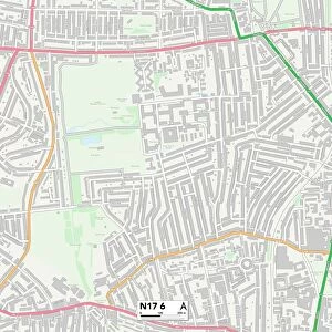
Haringey N17 6 Map

![]()
Wall Art and Photo Gifts from Map Marketing
Haringey N17 6 Map
Postcode Sector Map of Haringey N17 6
Media ID 19976170
Adams Road Alton Road Apple Tree Road Belmont Avenue Belmont Road Belton Road Broadwater Road Bruce Grove Chandos Road Chaplin Road Chester Road Clacton Road Crossfield Road Drayton Road Elmhurst Road Field Road Forest Gardens Forster Road Gloucester Road Grant Close Greyhound Road Griffin Road Haringey Hastings Road Higham Road Kitchener Road Linley Road Lismore Road Marden Road Morrison Avenue Mount Pleasant Road Napier Road Newlyn Road Pendennis Road Radley Road Ranelagh Road Ripon Road Somerset Close St Margarets Road Steele Road Strode Road The Avenue Walpole Road Whitley Road Wilmot Road Wimborne Road Winchelsea Road Windrush Close Woodside Gardens
FEATURES IN THESE COLLECTIONS
> Arts
> Landscape paintings
> Forest and woodland scenes
> Forest artwork
> Europe
> United Kingdom
> England
> London
> Boroughs
> Haringey
> Europe
> United Kingdom
> England
> Somerset
> Drayton
> Europe
> United Kingdom
> England
> Somerset
> Related Images
> Map Marketing
> Postcode Sector Maps
> N - London N
> Maps and Charts
> Related Images
MADE IN THE USA
Safe Shipping with 30 Day Money Back Guarantee
FREE PERSONALISATION*
We are proud to offer a range of customisation features including Personalised Captions, Color Filters and Picture Zoom Tools
SECURE PAYMENTS
We happily accept a wide range of payment options so you can pay for the things you need in the way that is most convenient for you
* Options may vary by product and licensing agreement. Zoomed Pictures can be adjusted in the Cart.