Home > Arts > Street art graffiti > Digital art > Vector illustrations
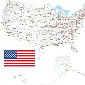
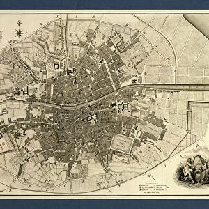
Modesto California US City Street Map

![]()
Wall Art and Photo Gifts from Fine Art Storehouse
Modesto California US City Street Map
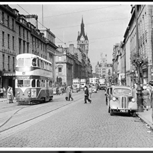
Vector Illustration of a City Street Map of Modesto, California, USA. Scale 1:60, 000.
All source data is in the public domain.
U.S. Geological Survey, US Topo
Used Layers:
USGS The National Map: National Hydrography Dataset (NHD)
USGS The National Map: National Transportation Dataset (NTD)
Unleash your creativity and transform your space into a visual masterpiece!
Frank Ramspott
Media ID 15055137
© Frank Ramspott, all rights reserved
Aerial View California City Map Computer Graphic Directly Above Downtown District Gray Road Map Text Digitally Generated Image Green Color White Color
FEATURES IN THESE COLLECTIONS
> Aerial Photography
> Related Images
> Animals
> Insects
> Hemiptera
> Green Scale
> Animals
> Mammals
> Cricetidae
> California Mouse
> Arts
> Contemporary art
> Digital artwork
> Street art
> Arts
> Landscape paintings
> Waterfall and river artworks
> River artworks
> Arts
> Portraits
> Pop art gallery
> Street art portraits
> Arts
> Street art graffiti
> Digital art
> Digital paintings
> Arts
> Street art graffiti
> Digital art
> Vector illustrations
> Fine Art Storehouse
> Map
> Street Maps
> Fine Art Storehouse
> Map
> USA Maps
> Maps and Charts
> Geological Map
> Maps and Charts
> Related Images
EDITORS COMMENTS
This print showcases a meticulously detailed city street map of Modesto, California, USA. The vector illustration presents an aerial view of the downtown district, highlighting the intricate network of roads and streets that shape this vibrant city. With a scale of 1:60,000, every corner and intersection is accurately depicted to provide a comprehensive overview for residents and visitors alike. The artist behind this masterpiece, Frank Ramspott, skillfully utilized various layers from publicly available data sources such as USGS The National Map: National Hydrography Dataset (NHD) and USGS The National Map: National Transportation Dataset (NTD). These reliable resources ensure the accuracy and authenticity of the map. Rendered in shades of gray with pops of green for parks and blue for water bodies like rivers and lakes, this digitally generated image captures both the physical geography and urban landscape. Devoid of people or any commercial elements, it allows viewers to focus solely on exploring the city's layout. Whether you are planning your next adventure or simply appreciate cartography as an art form, this visually striking print is sure to captivate your imagination. Hang it proudly on your wall to admire Modesto's unique charm while adding a touch of sophistication to your space.
MADE IN THE USA
Safe Shipping with 30 Day Money Back Guarantee
FREE PERSONALISATION*
We are proud to offer a range of customisation features including Personalised Captions, Color Filters and Picture Zoom Tools
SECURE PAYMENTS
We happily accept a wide range of payment options so you can pay for the things you need in the way that is most convenient for you
* Options may vary by product and licensing agreement. Zoomed Pictures can be adjusted in the Cart.