Home > Historic > Medieval architecture > Castles and fortresses > Ancient fortifications
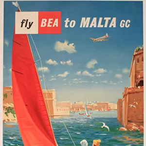
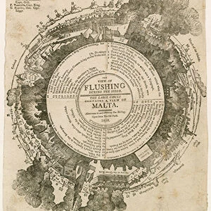
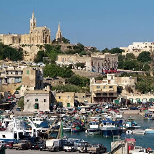
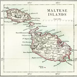
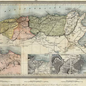
Map of the port of Malta, its fortifications and the castle. 18th century engraving

![]()
Wall Art and Photo Gifts from Fine Art Finder
Map of the port of Malta, its fortifications and the castle. 18th century engraving
LSE4087322 Map of the port of Malta, its fortifications and the castle. 18th century engraving. by Unknown artist, (18th century); Private Collection; (add.info.: Map of the port of Malta, its fortifications and the castle. 18th century engraving.); Photo eLeonard de Selva; out of copyright
Media ID 22545376
© Leonard de Selva / Bridgeman Images
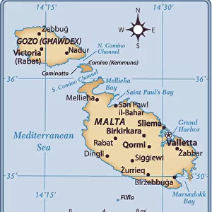
Malta Mediterranean Sea Urban Planning Geographical Map
FEATURES IN THESE COLLECTIONS
> Arts
> Contemporary art
> Landscapes
> Urban landscapes
> Arts
> Realistic drawings
> Urban landscapes
> Fine art
> Arts
> Realistic drawings
> Urban landscapes
> Urban artwork
> Arts
> Street art graffiti
> Urban art
> Landscape paintings
> Europe
> Malta
> Related Images
> Fine Art Finder
> Artists
> Unknown Artist
> Historic
> Medieval architecture
> Castles and fortresses
> Ancient fortifications
> Maps and Charts
> Malta
EDITORS COMMENTS
This 18th-century engraving takes us back in time to the bustling port of Malta. The intricate details of this map showcase not only the geographical layout but also the fortifications and castle that once guarded this strategic Mediterranean harbor. The artist, unknown but undoubtedly talented, has captured the essence of urban planning with precision and artistry. Every street, every building is meticulously depicted, offering a glimpse into the vibrant cityscape that thrived during this era. As we delve deeper into the image, our eyes are drawn to a variety of elements. A fleet of boats gracefully glides across the sparkling waters, symbolizing the importance of maritime transport in shaping Malta's history. The landscape surrounding the port exudes a sense of tranquility and beauty unique to coastal regions. This print serves as both an educational tool for geography enthusiasts and a visual feast for those who appreciate historical artwork. It allows us to explore Malta's rich past through its architectural marvels and strategic positioning within the Mediterranean Sea. Leonard de Selva's expert photography captures every minute detail with clarity, ensuring that even centuries later, viewers can immerse themselves in this scene. This print is a testament to how fine art can preserve history while simultaneously igniting our imagination about bygone eras.
MADE IN THE USA
Safe Shipping with 30 Day Money Back Guarantee
FREE PERSONALISATION*
We are proud to offer a range of customisation features including Personalised Captions, Color Filters and Picture Zoom Tools
SECURE PAYMENTS
We happily accept a wide range of payment options so you can pay for the things you need in the way that is most convenient for you
* Options may vary by product and licensing agreement. Zoomed Pictures can be adjusted in the Cart.