Home > Animals > Mammals > Muridae > Desert Mouse
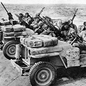
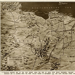
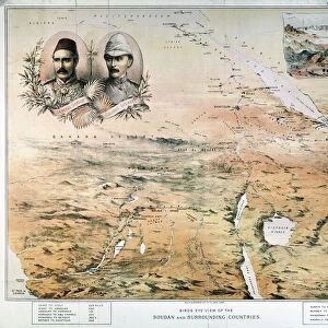
Map of the war in North Africa by G. H. Davis

![]()
Wall Art and Photo Gifts from Mary Evans Picture Library
Map of the war in North Africa by G. H. Davis
The war in North Africa: a strategic contour map of the desert arena during the Second World War. Conflict began there in September 1940. Date: 1942
Mary Evans Picture Library makes available wonderful images created for people to enjoy over the centuries
Media ID 14133309
© Illustrated London News Ltd/Mary Evans
1941 1942 Algeria Area Arena Conflict Contour Davis Desert Libya Maps Mediterranean Sahara Strategic Sudan
FEATURES IN THESE COLLECTIONS
> Africa
> Algeria
> Related Images
> Africa
> Egypt
> Related Images
> Africa
> Libya
> Related Images
> Africa
> Related Images
> Africa
> Sudan
> Related Images
> Animals
> Mammals
> Muridae
> Desert Mouse
EDITORS COMMENTS
This evocative map, titled "The War in North Africa: A Strategic Contour Map of the Desert Arena During the Second World War," was created by renowned cartographer G.H. Davis in 1942. The map provides a detailed and intricate representation of the North African theater of war during this pivotal period in world history. The conflict in North Africa began in September 1940, with the Italian invasion of Egypt and Libya, and intensified throughout 1941 with the British counteroffensives and the entry of the United States into the war. The map covers a vast area, stretching from the Mediterranean Sea in the north to the Red Sea in the east, and from the Egyptian border with Sudan in the west to the Algerian border with Tunisia in the west. The intricate contour lines and topographical details provide a visual representation of the challenging desert terrain that both Axis and Allied forces had to navigate. Key locations and battles are marked on the map, including Tobruk, El Alamein, and Kasserine Pass, which played significant roles in the outcome of the war in North Africa. The map also highlights the strategic importance of the Red Sea and the Suez Canal, which were crucial for the transportation of supplies and reinforcements to the Allied forces. The map's historical significance lies in its ability to convey the complex strategic landscape of the North African campaign during the Second World War. It offers a unique perspective on the military tactics and maneuvers that shaped the course of the conflict, and serves as a reminder of the sacrifices and challenges faced by the soldiers and civilians who lived through this tumultuous time. G.H. Davis's "The War in North Africa: A Strategic Contour Map of the Desert Arena During the Second World War" is a valuable historical document that continues to captivate scholars, military historians, and anyone interested in the history of the Second World War in North Africa.
MADE IN THE USA
Safe Shipping with 30 Day Money Back Guarantee
FREE PERSONALISATION*
We are proud to offer a range of customisation features including Personalised Captions, Color Filters and Picture Zoom Tools
SECURE PAYMENTS
We happily accept a wide range of payment options so you can pay for the things you need in the way that is most convenient for you
* Options may vary by product and licensing agreement. Zoomed Pictures can be adjusted in the Cart.