Home > Europe > United Kingdom > England > Birmingham > Area > Handsworth
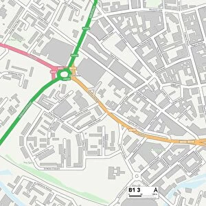
Birmingham B21 8 Map

![]()
Wall Art and Photo Gifts from Map Marketing
Birmingham B21 8 Map
Postcode Sector Map of Birmingham B21 8
Media ID 19965345
Albion Road Astley Road Austin Road Avenue Road Beacon Way Birmingham Camp Lane Carlton Avenue Cranbrook Road Dairy Way Farnham Road Friary Gardens Grafton Road Greenhill Road Hamilton Road Holyhead Road Island Road Larch Avenue Newcombe Road Park Lane Raleigh Close Regent Road Sampson Close Uplands Road Westbourne Road Willow Drive Handsworth
FEATURES IN THESE COLLECTIONS
> Europe
> United Kingdom
> England
> Birmingham
> Area
> Handsworth
> Europe
> United Kingdom
> England
> London
> Sights
> Regents Park
> Europe
> United Kingdom
> Scotland
> Strathclyde
> Hamilton
> Europe
> United Kingdom
> Wales
> Anglesey
> Holyhead
> Europe
> United Kingdom
> Wales
> Gwynedd
> Holyhead
> Map Marketing
> Postcode Sector Maps
> B - Birmingham
> Maps and Charts
> Related Images
MADE IN THE USA
Safe Shipping with 30 Day Money Back Guarantee
FREE PERSONALISATION*
We are proud to offer a range of customisation features including Personalised Captions, Color Filters and Picture Zoom Tools
SECURE PAYMENTS
We happily accept a wide range of payment options so you can pay for the things you need in the way that is most convenient for you
* Options may vary by product and licensing agreement. Zoomed Pictures can be adjusted in the Cart.