Home > Asia > Sri Lanka > Maps
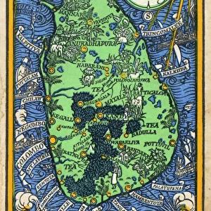
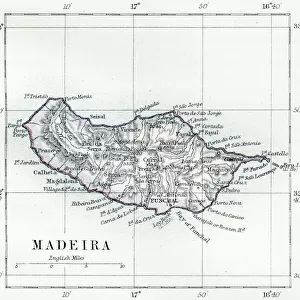
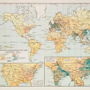
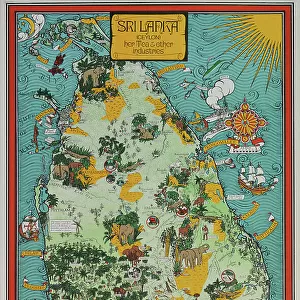
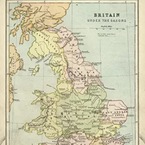
Srilanka former Ceylon map 1895

![]()
Wall Art and Photo Gifts from Fine Art Storehouse
Srilanka former Ceylon map 1895
Meyers Konversations-Lexikon. Ein Nachschlagewerk des allgemeinen Wissens, 5th edition 17 volumes Bibliographisches Institut - Leipzig 1895-1897
Unleash your creativity and transform your space into a visual masterpiece!
THEPALMER
Media ID 13609227
© This content is subject to copyright
Ceylon Indian Subcontinent Island South Asia Sri Lanka Srilanka
FEATURES IN THESE COLLECTIONS
> Asia
> Related Images
> Asia
> Sri Lanka
> Related Images
> Fine Art Storehouse
> Map
> Historical Maps
> Fine Art Storehouse
> Map
> USA Maps
> Maps and Charts
> Related Images
> North America
> United States of America
> Maps
EDITORS COMMENTS
This print showcases a historical map of Sri Lanka, formerly known as Ceylon, dating back to 1895. The map is sourced from the renowned Meyers Konversations-Lexikon, an extensive encyclopedia published in Leipzig between 1895 and 1897. With its intricate engravings and detailed cartography, this illustration provides a fascinating glimpse into the island's geography during that era. The vertical composition of the print allows viewers to appreciate the entirety of Sri Lanka's distinctive shape within the larger context of the Indian subcontinent. This ancient landmass stands out with its lush greenery and surrounded by vast bodies of water. The engraving technique employed in creating this map adds an element of elegance and sophistication to its overall aesthetic. As we delve into history through this image, it reminds us of how Sri Lanka has evolved over time while retaining its unique cultural heritage. From colonial influences to independence struggles, this island nation has witnessed significant transformations throughout its rich past. Whether you are a history enthusiast or simply appreciate fine art, this remarkable print by THEPALMER offers both visual appeal and educational value. It serves as a testament to the skillful craftsmanship involved in producing such intricate maps during an era when cartography was still in its prime.
MADE IN THE USA
Safe Shipping with 30 Day Money Back Guarantee
FREE PERSONALISATION*
We are proud to offer a range of customisation features including Personalised Captions, Color Filters and Picture Zoom Tools
SECURE PAYMENTS
We happily accept a wide range of payment options so you can pay for the things you need in the way that is most convenient for you
* Options may vary by product and licensing agreement. Zoomed Pictures can be adjusted in the Cart.