Home > Europe > Italy > Veneto > Venice
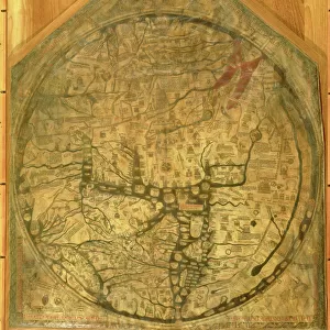
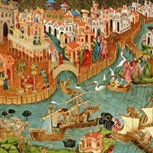
Fra Mauro map, 1460 (map)
")
![]()
Wall Art and Photo Gifts from Fine Art Finder
Fra Mauro map, 1460 (map)
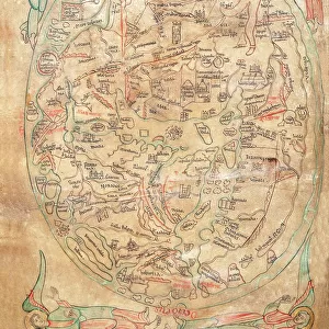
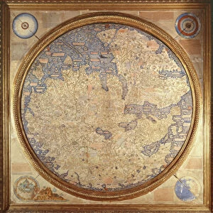
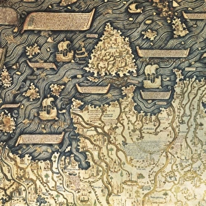
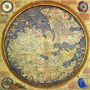
529889 Fra Mauro map, 1460 (map) by Italian School, (15th century); (add.info.: The Fra Mauro Map orientation (South at the top).is considered the greatest memorial of medieval cartography. by the Venetian monk Fra Mauro. It is a circular planisphere drawn on parchment and set in a wooden frame, about two meters in diameter); Universal History Archive/UIG
Media ID 25060192
© Universal History Archive/UIG / Bridgeman Images
1460 Circular Considered Drawn Frame Greatest Mapping Memorial Orientation Parchment Planisphere South Upside Down Venetians World Map Diameter Early Xv Century Late Xv Century Mauro Meters
FEATURES IN THESE COLLECTIONS
> Arts
> Art Movements
> Medieval Art
> Arts
> Artists
> I
> Italian School Italian School
> Europe
> Italy
> Veneto
> Related Images
> Europe
> Italy
> Veneto
> Venice
> Fine Art Finder
> Artists
> Eric Harald Macbeth Robertson
> Fine Art Finder
> Artists
> Italian School
> Fine Art Finder
> Temp Classification
> Maps and Charts
> Early Maps
> Maps and Charts
> Italy
> Maps and Charts
> Related Images
> Maps and Charts
> World
EDITORS COMMENTS
This print showcases the renowned Fra Mauro map, created in 1460 by the Venetian monk Fra Mauro. Considered a masterpiece of medieval cartography, this circular planisphere is drawn on parchment and encased in a magnificent wooden frame with a diameter of approximately two meters. The unique aspect of this map lies in its orientation, with South positioned at the top instead of the traditional North. The Fra Mauro map stands as an extraordinary memorial to the ingenuity and skill of its creator. It offers a comprehensive depiction of the world during the 15th century, providing invaluable insights into mapping and geography from that era. Its intricate details and meticulous craftsmanship make it one of history's greatest cartographic achievements. As we gaze upon this remarkable artwork, we are transported back in time to witness how early explorers navigated uncharted territories. The precision with which landmasses, coastlines, and even cultural landmarks are depicted demonstrates Fra Mauro's dedication to accuracy. This photograph captures not only the beauty but also the historical significance embodied within this piece. It serves as a reminder that maps have always played an essential role in shaping our understanding of the world around us. With its vibrant colors and intricate design, this image invites us to delve into centuries past while appreciating both Italian artistry and scientific exploration.
MADE IN THE USA
Safe Shipping with 30 Day Money Back Guarantee
FREE PERSONALISATION*
We are proud to offer a range of customisation features including Personalised Captions, Color Filters and Picture Zoom Tools
SECURE PAYMENTS
We happily accept a wide range of payment options so you can pay for the things you need in the way that is most convenient for you
* Options may vary by product and licensing agreement. Zoomed Pictures can be adjusted in the Cart.