Home > Arts > Artists > B > Joan Blaeu
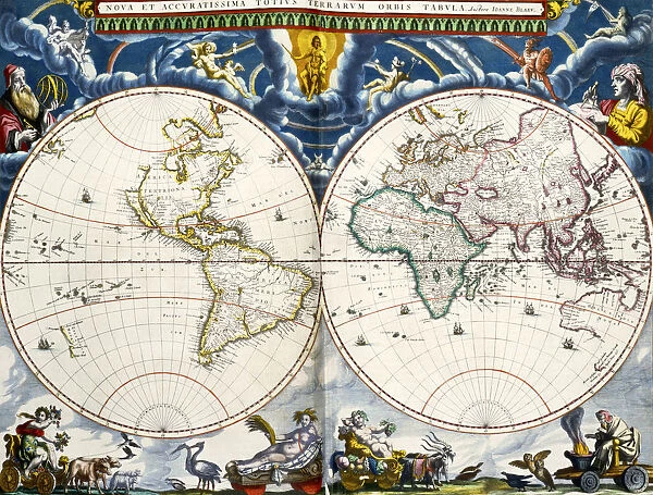
Nova et accuratissima totius terrarum orbis tabula
![]()

Wall Art and Photo Gifts from Universal Images Group (UIG)
Nova et accuratissima totius terrarum orbis tabula
Nova et accuratissima totius terrarum orbis tabula. A new and most accurate map of all the worlds countries. World map by Joan Blaeu (1596-1673) dating from the mid 17th century. The east coast of Australia remains unexplored and California is portrayed as an island
Universal Images Group (UIG) manages distribution for many leading specialist agencies worldwide
Media ID 20165129
© Ken Welsh / Design Pics
17th Accurate Australia Australian California Century Coast Countries East Island Joan Nova Blaeu Most Orbis Tabula Terrarum Totius Unexplored Worlds
FEATURES IN THESE COLLECTIONS
> Arts
> Artists
> B
> Joan Blaeu
> Maps and Charts
> Related Images
> Maps and Charts
> World
> Oceania
> Australia
> Related Images
> Universal Images Group (UIG)
> History
> Historical Maps
EDITORS COMMENTS
This print showcases the historical masterpiece titled "Nova et accuratissima totius terrarum orbis tabula" by Joan Blaeu, a renowned cartographer from the mid 17th century. This extraordinary map, dating back to that era, offers an intriguing glimpse into how our world was perceived at the time. The intricate details and precision of this map are truly remarkable. It provides a comprehensive view of all the countries in the world during that period, making it an invaluable resource for historians and geography enthusiasts alike. However, what makes this particular map even more fascinating is its depiction of California as an island and the unexplored east coast of Australia. Intriguingly, this representation reflects the limited knowledge explorers had about these regions during Blaeu's time. The belief that California was separated from mainland North America persisted until further exploration proved otherwise. Similarly, Australia's eastern coastline remained largely unknown to Europeans until Captain James Cook's voyage in 1770. As we gaze upon this exceptional piece of cartographic artistry captured in this print by Universal History Archive from Universal Images Group (UIG), we are transported back to a time when our understanding of the world was still evolving. It serves as a reminder of how far we have come in unraveling Earth's mysteries while also appreciating those who paved the way for future discoveries.
MADE IN THE USA
Safe Shipping with 30 Day Money Back Guarantee
FREE PERSONALISATION*
We are proud to offer a range of customisation features including Personalised Captions, Color Filters and Picture Zoom Tools
SECURE PAYMENTS
We happily accept a wide range of payment options so you can pay for the things you need in the way that is most convenient for you
* Options may vary by product and licensing agreement. Zoomed Pictures can be adjusted in the Cart.

