Home > Universal Images Group (UIG) > Art > Painting, Sculpture & Prints > Illustration And Painting
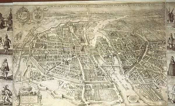
Map of Paris by Matthieu Merian, opperplate, printed in Paris 1615
![]()

Wall Art and Photo Gifts from Universal Images Group (UIG)
Map of Paris by Matthieu Merian, opperplate, printed in Paris 1615
Cartography, France, 17th century. Map of Paris created by Matthieu Merian, Paris 1615. Copperplate, 53 x 105 cm
Universal Images Group (UIG) manages distribution for many leading specialist agencies worldwide
Media ID 9455205
© DEA PICTURE LIBRARY
17th Century Capital Cities City Cityscape Direction Guidance Paris River Seine Western Script
EDITORS COMMENTS
This print showcases a remarkable piece of cartographic history - the "Map of Paris" created by Matthieu Merian in 1615. Measuring an impressive 53 x 105 cm, this copperplate masterpiece offers a fascinating glimpse into the city's layout during the 17th century. With its intricate details and precise craftsmanship, Merian's map serves as both a work of art and a practical tool for navigation. The map highlights the direction and guidance one would need to traverse through the bustling streets of Paris at that time. It captures the essence of travel and exploration, inviting viewers to embark on a journey back in time. The Map of Paris also provides valuable insights into the physical geography of France's capital city. From its iconic River Seine meandering gracefully through its heart to its sprawling cityscape dotted with architectural marvels, this illustration beautifully portrays Paris' unique charm. As we admire this historical artifact, it is impossible not to appreciate Merian's skillful use of Western script and his meticulous attention to detail. This outdoor scene transports us back to a bygone era when maps were meticulously crafted works of art rather than digital representations on screens. This print from Universal Images Group (UIG) allows us to cherish this significant piece without commercial intentions but instead encourages us to delve deeper into our appreciation for history, culture, and artistic expression.
MADE IN THE USA
Safe Shipping with 30 Day Money Back Guarantee
FREE PERSONALISATION*
We are proud to offer a range of customisation features including Personalised Captions, Color Filters and Picture Zoom Tools
SECURE PAYMENTS
We happily accept a wide range of payment options so you can pay for the things you need in the way that is most convenient for you
* Options may vary by product and licensing agreement. Zoomed Pictures can be adjusted in the Cart.


