Home > Universal Images Group (UIG) > Art > Painting, Sculpture & Prints > Cartography
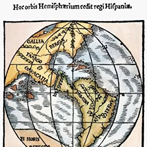
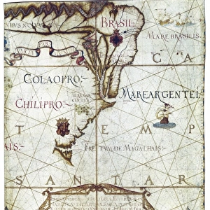
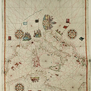
Nautical planisphere by Andreas Homen, printed in Portugal, 1559

![]()
Wall Art and Photo Gifts from Universal Images Group (UIG)
Nautical planisphere by Andreas Homen, printed in Portugal, 1559
Cartography, Portugal, 16th century. Nautical planisphere by Andreas Homen, 1559
Universal Images Group (UIG) manages distribution for many leading specialist agencies worldwide
Media ID 9503019
© DEA PICTURE LIBRARY
16th Century Astronomy Direction Guidance Panoramic Planisphere Western Script
EDITORS COMMENTS
This print showcases a remarkable piece of cartographic history - the Nautical planisphere by Andreas Homen, printed in Portugal in 1559. Steeped in rich cultural significance, this 16th-century masterpiece combines elements of panoramic artistry, astronomy, and navigation to guide seafarers across uncharted waters. The planisphere's intricate design offers a glimpse into the past, revealing how sailors relied on such maps for direction during their perilous journeys. Its horizontal layout captures the vastness of the sea while providing essential information about physical geography and landmarks along various trade routes. As an illustration and painting crafted with meticulous detail, this artwork exemplifies both artistic skill and scientific knowledge. The absence of people allows viewers to focus solely on the map's beauty and complexity. Western script adorns its surface, adding an air of authenticity to its historical value. Gazing at this nautical planisphere transports us back in time when exploration was synonymous with adventure and discovery. It serves as a testament to human curiosity and our relentless pursuit of knowledge beyond known horizons. Preserved by Universal Images Group (UIG), this print invites us to appreciate not only its aesthetic appeal but also its role as a significant artifact from Portugal's cartographic heritage. Let it inspire you to embark on your own journey through history or simply marvel at the ingenuity that shaped our understanding of travel and navigation centuries ago.
MADE IN THE USA
Safe Shipping with 30 Day Money Back Guarantee
FREE PERSONALISATION*
We are proud to offer a range of customisation features including Personalised Captions, Color Filters and Picture Zoom Tools
SECURE PAYMENTS
We happily accept a wide range of payment options so you can pay for the things you need in the way that is most convenient for you
* Options may vary by product and licensing agreement. Zoomed Pictures can be adjusted in the Cart.