Home > Arts > Landscape paintings > Waterfall and river artworks > River artworks
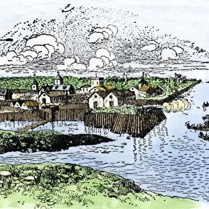
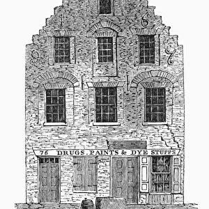
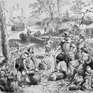
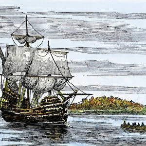
John Smiths map of Jamestown

![]()
Wall Art and Photo Gifts from North Wind
John Smiths map of Jamestown
Map of Jamestown settlement, Virginia.
Hand-colored 19th-century woodcut reproduction from Smiths Historie of Virginia
North Wind Picture Archives brings history to life with stock images and hand-colored illustrations
Media ID 5882495
© North Wind Picture Archives
1600s 17th Century Atlantic Atlantic Coast Colonial Colony Document English English Colony James River Jamestown Jamestown Colony John Smith Settlement South Southern Virginia
FEATURES IN THESE COLLECTIONS
> Arts
> Landscape paintings
> Waterfall and river artworks
> River artworks
> Historic
> Colonial America illustrations
> Colonial America
> Historic
> Colonial America illustrations
> Historic
> Colonial history
> Colonial art and artists
> North America
> Related Images
> North Wind Picture Archives
> Maps
> South America
> Related Images
EDITORS COMMENTS
This 19th-century woodcut reproduction of John Smith's map of Jamestown takes us back in time to the early days of America's history. Hand-colored with meticulous detail, this vintage print showcases the rich heritage and traditional roots that shaped the southern region of Virginia. As we gaze upon this historic illustration, we are transported to the 17th century when English settlers first established their colony on American soil. The map depicts Jamestown settlement nestled along the picturesque James River, a vital lifeline for these pioneers as they navigated through uncharted territories. Every line and symbol on this document tells a story of resilience and determination. It serves as a testament to the audacious spirit that fueled exploration during those times. This artful representation not only captures geographical accuracy but also provides insight into the colonial era's political boundaries and landmarks. The significance of Jamestown cannot be overstated; it was here that North America witnessed its earliest English colony take root. This visual treasure allows us to appreciate how far our nation has come since those humble beginnings. Let this remarkable piece transport you back in time, offering glimpses into an era where dreams were forged against all odds. A true masterpiece capturing both historical importance and artistic brilliance, reminding us of our united states' enduring legacy along the Atlantic coast.
MADE IN THE USA
Safe Shipping with 30 Day Money Back Guarantee
FREE PERSONALISATION*
We are proud to offer a range of customisation features including Personalised Captions, Color Filters and Picture Zoom Tools
SECURE PAYMENTS
We happily accept a wide range of payment options so you can pay for the things you need in the way that is most convenient for you
* Options may vary by product and licensing agreement. Zoomed Pictures can be adjusted in the Cart.