Home > Maps and Charts > Africa
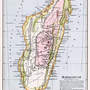
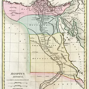
Map of Africa 1818

![]()
Wall Art and Photo Gifts from Mary Evans Picture Library
Map of Africa 1818
Map of Africa in 1818 Date: 1818
Mary Evans Picture Library makes available wonderful images created for people to enjoy over the centuries
Media ID 20140453
© Bubblepunk
FEATURES IN THESE COLLECTIONS
> Africa
> Related Images
> Maps and Charts
> Related Images
> Mary Evans Prints Online
> New Images July 2020
EDITORS COMMENTS
This map print, titled "Africa," dates back to the year 1818, offering a fascinating glimpse into the geographical knowledge of the continent during the early 19th century. The map, available through Mary Evans Prints Online, reveals the intricate details of Africa's vast and complex terrain, with its myriad of rivers, mountains, and coastal features meticulously delineated. At the time this map was created, European exploration and colonization of Africa were in their infancy, and the cartographic understanding of the continent was far from complete. Consequently, the map reflects the incomplete and often inaccurate knowledge of the region, with numerous blank spaces and misplaced borders. For instance, the location of the source of the Nile River, a major mystery at the time, is marked with a question mark. Despite its limitations, this map is an essential historical document, providing valuable insights into the state of geographical knowledge during the early 19th century. It also serves as a reminder of the exploratory spirit that drove European powers to venture into Africa and reshape its political and cultural landscape over the following decades. The map's antique charm is further enhanced by its intricate cartouche, which features an elegant depiction of an African elephant, a rhinoceros, and various exotic birds, symbolizing the exoticism and allure of the African continent that captivated European imaginations during this period. Overall, this map print is a must-have for anyone interested in the history of Africa, cartography, or the age of exploration.
MADE IN THE USA
Safe Shipping with 30 Day Money Back Guarantee
FREE PERSONALISATION*
We are proud to offer a range of customisation features including Personalised Captions, Color Filters and Picture Zoom Tools
SECURE PAYMENTS
We happily accept a wide range of payment options so you can pay for the things you need in the way that is most convenient for you
* Options may vary by product and licensing agreement. Zoomed Pictures can be adjusted in the Cart.