Home > Animals > Mammals > Soricidae > Niger
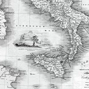
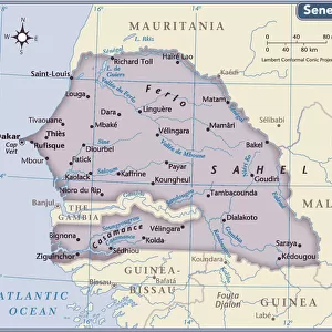
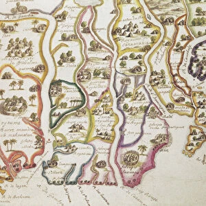
Map of the courses of the Niger River, Senegal

![]()
Wall Art and Photo Gifts from Mary Evans Picture Library
Map of the courses of the Niger River, Senegal
Map of the courses of the Niger River, Senegal River and Gambia River in West Africa. Handcoloured copperplate engraving from Giulio Ferrarios Costumes Ancient and Modern of the Peoples of the World, Florence, 1834
Mary Evans Picture Library makes available wonderful images created for people to enjoy over the centuries
Media ID 23174396
© Florilegius/Mary Evans
Course Ferrario Gambia Giulio Niger Peoples Senegal
FEATURES IN THESE COLLECTIONS
> Africa
> The Gambia
> Maps
> Animals
> Mammals
> Soricidae
> Niger
> Arts
> Artists
> F
> Giulio Ferrario
> Maps and Charts
> Early Maps
> Maps and Charts
> World
> Mary Evans Prints Online
> New Images August 2021
EDITORS COMMENTS
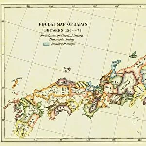
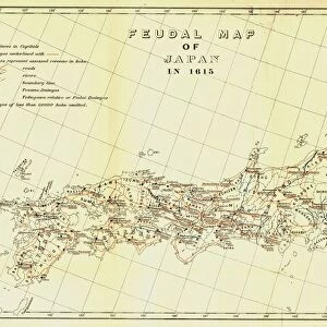
This exquisite handcoloured copperplate engraving, taken from Giulio Ferrario's "Costumes Ancient and Modern of the Peoples of the World," published in Florence in 1834, provides a fascinating glimpse into the geography of West Africa during the early 19th century. The map meticulously depicts the courses of three major rivers in the region: the Niger, Senegal, and Gambia. The Niger River, Africa's third-longest river, is shown flowing from its source in Guinea, passing through Mali, Niger, and Nigeria before emptying into the Atlantic Ocean. The Senegal River, which runs through Mauritania and Senegal, is also depicted, as it flows from its source in the Guinean Highlands towards the Atlantic Ocean. The Gambia River, a major tributary that empties into the Atlantic Ocean, is shown branching off the Senegal River near its northern end. The intricate details of this map reveal not only the geographical features of the region but also the historical significance of these waterways. The Niger River was a vital trade route for the trans-Saharan trade, connecting the Sahelian region with the Atlantic Coast. The Senegal River, on the other hand, was a crucial water source for the ancient Ghana Empire and later served as a strategic military and commercial route during European colonization. The Gambia River was a significant trading center for the British, who established the Gambia Colony in 1821. This map is a testament to the rich historical, cultural, and geographical heritage of West Africa. Its intricate details and beautiful handcolouring make it an essential addition to any collection of historical maps or illustrations of Africa. Giulio Ferrario's "Costumes Ancient and Modern of the Peoples of the World" was a groundbreaking work that showcased the diversity of the world's peoples and their cultures. This map is a reminder of the importance of preserving and celebrating the history and heritage of the past.
MADE IN THE USA
Safe Shipping with 30 Day Money Back Guarantee
FREE PERSONALISATION*
We are proud to offer a range of customisation features including Personalised Captions, Color Filters and Picture Zoom Tools
SECURE PAYMENTS
We happily accept a wide range of payment options so you can pay for the things you need in the way that is most convenient for you
* Options may vary by product and licensing agreement. Zoomed Pictures can be adjusted in the Cart.