Home > North America > United States of America > Maps
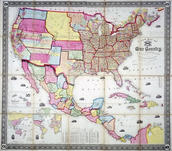
Map of the USA 1855
![]()

Wall Art and Photo Gifts from Mary Evans Picture Library
Map of the USA 1855
Mary Evans Picture Library makes available wonderful images created for people to enjoy over the centuries
Media ID 7403951
© Mary Evans Picture Library 2015 - https://copyrighthub.org/s0/hub1/creation/maryevans/MaryEvansPictureID/10474562
FEATURES IN THESE COLLECTIONS
> Maps and Charts
> Related Images
> Mary Evans Prints Online
> National Archives
> North America
> United States of America
> Maps
EDITORS COMMENTS
This Map of the USA from 1855, an intriguing artifact from the 19th century, offers a fascinating glimpse into the geographical knowledge and political landscape of America during that era. The map, which measures approximately 13.7 x 9.2 inches, is a testament to the significant advancements in cartography during the 19th century. The map is adorned with intricate details, including state and territorial boundaries, major rivers, and bodies of water. Notable features include the newly acquired territories of California, Nevada, Utah, and New Mexico, which had only recently been explored and settled. The map also highlights the vast expanse of the western frontier, which was still largely unexplored and unknown. The Map of the USA 1855 is a reflection of the political climate of the time, with the Mexican Cession clearly marked, indicating the territories that had been acquired from Mexico following the Mexican-American War. The map also includes the Oregon Treaty of 1846, which settled the boundary dispute between the United States and Great Britain. This map is an essential addition to any collection of American history or cartography. Its intricate details and historical significance make it a valuable resource for scholars, educators, and enthusiasts alike. The Map of the USA 1855 is a captivating reminder of the exploration, expansion, and growth of the United States during the 19th century. This map, which is part of the Mary Evans Prints Online collection, is a rights-managed image, meaning that it is protected by copyright and can only be used with proper permission and attribution. It is an important reminder of the importance of respecting intellectual property and the role that historical documents play in shaping our understanding of the past.
MADE IN THE USA
Safe Shipping with 30 Day Money Back Guarantee
FREE PERSONALISATION*
We are proud to offer a range of customisation features including Personalised Captions, Color Filters and Picture Zoom Tools
SECURE PAYMENTS
We happily accept a wide range of payment options so you can pay for the things you need in the way that is most convenient for you
* Options may vary by product and licensing agreement. Zoomed Pictures can be adjusted in the Cart.

