Home > Arts > Photorealistic artworks > Detailed art pieces > Masterful detailing in art
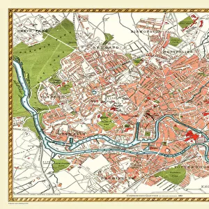
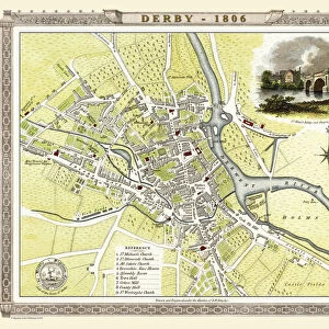
Old Map of St Albans 1810 by Cole and Roper

![]()
Wall Art and Photo Gifts from MapSeeker
Old Map of St Albans 1810 by Cole and Roper
An attractive and detailed early 19th century reproduction town plan of St Albans 1810. First published by Cole and Roper as a finely engraved series of county maps and town plans which were initially issued in parts and then together as The British Atlas in 1810
Welcome to the Mapseeker Image library and enter an historic gateway to one of the largest on-line collections of Historic Maps, Nostalgic Views, Vista's and Panorama's from a World gone by.
Media ID 20348048
© Mapseeker Publishing Ltd
Cole And Roper Historic Map Old Town Plan Town Plan St Albans
FEATURES IN THESE COLLECTIONS
> Arts
> Photorealistic artworks
> Detailed art pieces
> Masterful detailing in art
> Maps and Charts
> Early Maps
> Maps and Charts
> Related Images
> MapSeeker
> British Town And City Plans
> English & Welsh PORTFOLIO
EDITORS COMMENTS
This print showcases an exquisite reproduction of the "Old Map of St Albans 1810" by Cole and Roper. Transporting us back to the early 19th century, this town plan offers a fascinating glimpse into the historic layout of St Albans. Originally published as part of a meticulously engraved series of county maps and town plans, this particular map was included in The British Atlas in 1810. The attention to detail on this map is truly remarkable, capturing every intricate aspect of St Albans' streets, buildings, and landmarks from over two centuries ago. It serves as a testament to the craftsmanship and dedication put forth by Cole and Roper during their time. As we explore this old town plan, we are drawn into its allure - imagining what life must have been like for residents navigating these very streets all those years ago. From bustling marketplaces to charming residential areas, it provides an invaluable historical record that allows us to connect with the past. Whether you're a history enthusiast or simply captivated by cartography, this historic St Albans map is sure to be a cherished addition to any collection. Its beauty lies not only in its accuracy but also in its ability to transport us back in time – reminding us of how our cities have evolved throughout history.
MADE IN THE USA
Safe Shipping with 30 Day Money Back Guarantee
FREE PERSONALISATION*
We are proud to offer a range of customisation features including Personalised Captions, Color Filters and Picture Zoom Tools
SECURE PAYMENTS
We happily accept a wide range of payment options so you can pay for the things you need in the way that is most convenient for you
* Options may vary by product and licensing agreement. Zoomed Pictures can be adjusted in the Cart.