Home > Animals > Farm > Cattle > Related Images
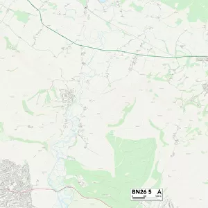
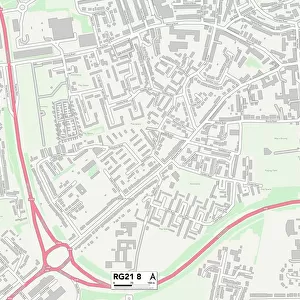
West Berkshire RG20 7 Map

![]()
Wall Art and Photo Gifts from Map Marketing
West Berkshire RG20 7 Map
Postcode Sector Map of West Berkshire RG20 7
Media ID 19980548
Abingdon Road Broad Street Browns Lane Bury Lane Church Hill Church Side Churchway Common Lane Cow Lane Dark Lane Downside Field Road High Street Holt Lane Long Lane Main Street Meads Close Mount Lane Mud Lane Old Street Palmer Close Pudding Lane Southend St Andrews Close The Gallops The Maltings The Pightle The Rookery Tower Hill West Berkshire West View Wick Lane Upper End
FEATURES IN THESE COLLECTIONS
> Animals
> Farm
> Cattle
> Related Images
> Animals
> Mammals
> Bovidae
> Sheep
> Architecture
> Towers
> Churches
> Europe
> United Kingdom
> England
> Berkshire
> East Fields
> Europe
> United Kingdom
> England
> Berkshire
> The Holt
> Europe
> United Kingdom
> England
> Berkshire
> The Mount
> Europe
> United Kingdom
> England
> Berkshire
> Related Images
> Europe
> United Kingdom
> England
> Berkshire
> Southend
> Europe
> United Kingdom
> England
> Berkshire
> Stanmore
> Europe
> United Kingdom
> England
> Berkshire
> Upper Green
> Map Marketing
> Postcode Sector Maps
> RG - Reading
MADE IN THE USA
Safe Shipping with 30 Day Money Back Guarantee
FREE PERSONALISATION*
We are proud to offer a range of customisation features including Personalised Captions, Color Filters and Picture Zoom Tools
SECURE PAYMENTS
We happily accept a wide range of payment options so you can pay for the things you need in the way that is most convenient for you
* Options may vary by product and licensing agreement. Zoomed Pictures can be adjusted in the Cart.