Home > Europe > United Kingdom > Scotland > Dumfries and Galloway > Langholm
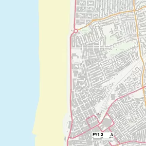
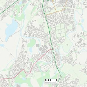
Bolton BL2 6 Map

![]()
Wall Art and Photo Gifts from Map Marketing
Bolton BL2 6 Map
Postcode Sector Map of Bolton BL2 6
Media ID 19966108
Alford Close Beechcroft Avenue Belvoir Street Blenheim Road Bolton Boundary Drive Boundary Street Bradley Lane Brent Close Brookfield Street Browns Road Burghley Close Bury New Road Bury Road Cemetery Road Chiltern Drive Churchill Street Clarendon Road Clegg Street Colenso Road Crompton Avenue Denton Road Falkland Road Glencoe Drive Gregory Avenue Heaton Road High Beeches Hilton Street Hind Street Kennedy Street Kenyon Road Long Lane Mafeking Road Meadow Lane Meadowside Avenue Mendip Close Mendip Drive Millfield Road Morar Drive Oakhill Close Old Oak Close Pretoria Road Rannoch Road Ribble Avenue Sackville Street Sandhurst Drive Singleton Avenue Somerton Road Stansfield Close Taylors Lane The Willows Vale Street
FEATURES IN THESE COLLECTIONS
> Europe
> United Kingdom
> Scotland
> Aberdeenshire
> Alford
> Europe
> United Kingdom
> Scotland
> Dumfries and Galloway
> Langholm
> Europe
> United Kingdom
> Scotland
> Dumfries and Galloway
> Moffat
> Europe
> United Kingdom
> Scotland
> Falkirk
> Carron
> Europe
> United Kingdom
> Scotland
> Falkirk
> Falkirk
> Europe
> United Kingdom
> Scotland
> Fife
> Falkland
> Europe
> United Kingdom
> Scotland
> Strathclyde
> East Kilbride
> Map Marketing
> Postcode Sector Maps
> BL - Bolton
> Maps and Charts
> Related Images
> South America
> Falkland Islands
> Stanley
MADE IN THE USA
Safe Shipping with 30 Day Money Back Guarantee
FREE PERSONALISATION*
We are proud to offer a range of customisation features including Personalised Captions, Color Filters and Picture Zoom Tools
SECURE PAYMENTS
We happily accept a wide range of payment options so you can pay for the things you need in the way that is most convenient for you
* Options may vary by product and licensing agreement. Zoomed Pictures can be adjusted in the Cart.