Home > Granger Art on Demand > American Civil War
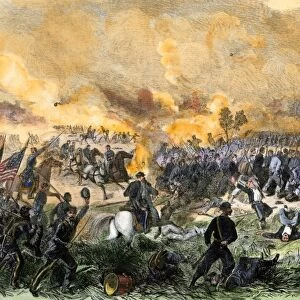
Topographical map of the battlefield at Antietam and Sharpsburg, Maryland, where Union and Confederate forces met in September 1862

![]()
Wall Art and Photo Gifts from Granger
Topographical map of the battlefield at Antietam and Sharpsburg, Maryland, where Union and Confederate forces met in September 1862
ANTIETAM, MARYLAND, 1862.
Topographical map of the battlefield at Antietam and Sharpsburg, Maryland, where Union and Confederate forces met in September 1862
Granger holds millions of images spanning more than 25,000 years of world history, from before the Stone Age to the dawn of the Space Age
Media ID 10408678
1862 Antietam Plan September Topography United States Sharpsburg
FEATURES IN THESE COLLECTIONS
> Granger Art on Demand
> American Civil War
> Granger Art on Demand
> Maps
> Granger Art on Demand
> Plans and Diagrams
EDITORS COMMENTS
This print showcases a topographical map of the historic battlefield at Antietam and Sharpsburg, Maryland. The year was 1862, and this site witnessed a significant clash between Union and Confederate forces during the American Civil War. The detailed map provides an invaluable visual representation of the terrain where these opposing armies met in September of that year. As we delve into this image, we are transported back to a crucial moment in American history. The map highlights key features such as the Antietam River flowing through the landscape, dividing it into distinct sections - North and Middle America. It allows us to visualize how both sides strategically maneuvered across this challenging terrain during one of the bloodiest battles in U. S. history. The significance of this battle cannot be overstated; it marked a turning point in the Civil War and had far-reaching consequences for both sides involved. This print serves as a reminder of those who fought bravely on these grounds, their sacrifices forever etched into history. For enthusiasts of military strategy or anyone seeking to understand our nation's past conflicts better, this topographical map offers valuable insights into the layout and challenges faced by troops during that fateful September in 1862 at Antietam and Sharpsburg, Maryland.
MADE IN THE USA
Safe Shipping with 30 Day Money Back Guarantee
FREE PERSONALISATION*
We are proud to offer a range of customisation features including Personalised Captions, Color Filters and Picture Zoom Tools
SECURE PAYMENTS
We happily accept a wide range of payment options so you can pay for the things you need in the way that is most convenient for you
* Options may vary by product and licensing agreement. Zoomed Pictures can be adjusted in the Cart.