Home > Arts > Street art graffiti > Digital art > Vector illustrations
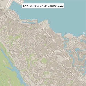
Sunnyvale California US City Street Map

![]()
Wall Art and Photo Gifts from Fine Art Storehouse
Sunnyvale California US City Street Map
Vector Illustration of a City Street Map of Sunnyvale, California, USA. Scale 1:60, 000.
All source data is in the public domain.
U.S. Geological Survey, US Topo
Used Layers:
USGS The National Map: National Hydrography Dataset (NHD)
USGS The National Map: National Transportation Dataset (NTD)
Unleash your creativity and transform your space into a visual masterpiece!
Frank Ramspott
Media ID 15055099
© Frank Ramspott, all rights reserved
Aerial View California City Map Computer Graphic Directly Above Downtown District Gray Road Map Text Digitally Generated Image Green Color Silicon Valley White Color
FEATURES IN THESE COLLECTIONS
> Aerial Photography
> Related Images
> Animals
> Insects
> Hemiptera
> Green Scale
> Animals
> Mammals
> Cricetidae
> California Mouse
> Arts
> Contemporary art
> Digital artwork
> Street art
> Arts
> Landscape paintings
> Waterfall and river artworks
> River artworks
> Arts
> Portraits
> Pop art gallery
> Street art portraits
> Arts
> Street art graffiti
> Digital art
> Digital paintings
> Arts
> Street art graffiti
> Digital art
> Vector illustrations
> Fine Art Storehouse
> Map
> Street Maps
> Fine Art Storehouse
> Map
> USA Maps
> Maps and Charts
> Geological Map
> Maps and Charts
> Related Images
EDITORS COMMENTS
This vibrant and detailed print showcases the city street map of Sunnyvale, California, USA. With a scale of 1:60,000, this vector illustration provides an accurate representation of the city's layout. The image captures the essence of Sunnyvale's bustling downtown district in Silicon Valley. The map incorporates various layers sourced from public domain data such as USGS The National Map: National Hydrography Dataset (NHD) and USGS The National Map: National Transportation Dataset (NTD). These layers ensure that important features like rivers, lakes, streets, and roads are accurately depicted. Designed by Frank Ramspott using computer graphics technology, this digitally generated image offers a bird's-eye view directly above Sunnyvale. The color palette includes shades of gray for urban areas, green for parks and open spaces, blue for water bodies like rivers and lakes, and white for roadways. With no people visible in the picture, the focus remains solely on the intricate cartography displayed. This print is perfect for those who appreciate fine art combined with geographical accuracy. Whether you're a resident or simply fascinated by maps and design elements alike, this piece will add sophistication to any space it graces.
MADE IN THE USA
Safe Shipping with 30 Day Money Back Guarantee
FREE PERSONALISATION*
We are proud to offer a range of customisation features including Personalised Captions, Color Filters and Picture Zoom Tools
SECURE PAYMENTS
We happily accept a wide range of payment options so you can pay for the things you need in the way that is most convenient for you
* Options may vary by product and licensing agreement. Zoomed Pictures can be adjusted in the Cart.